Accessibility

Font Size

100% 150% 200%

Background Colour

Default Contrast
Close Reset

Stobs Station

Footbridge (Period Unassigned), Railway Station (19th Century)

Site Name Stobs Station

Classification Footbridge (Period Unassigned), Railway Station (19th Century)

Alternative Name(s) The Waverley Line; The Border Union Railway; Stobs Halt; Barns Station

Canmore ID 284484

Site Number NT50NW 25.02

NGR NT 50483 09731

Datum OSGB36 - NGR

Permalink http://canmore.org.uk/site/284484

Ordnance Survey licence number AC0000807262. All rights reserved.
Canmore Disclaimer. © Bluesky International Limited 2025. Public Sector Viewing Terms

Toggle Aerial | View on large map

Digital Images

Interior.  Detail of fireplace in ticket office.
Interior.  Detail of fireplace in ticket office.View from NW of footbridge.Oblique aerial view centred on the viaduct with the railway station adjacent, taken from the NE.View from SSE showing station masters house.Oblique aerial view centred on the viaduct with the railway station adjacent, taken from the S.View from SSE showing platforms, footbridge and station masters house.Detail of ticket issuing window in S elevation of ticket and goods office, Stobs railway stationOblique aerial view centred on Stobs Station and the Barns Viaduct, taken from the W.View from NNW of platforms and footbridge.Oblique aerial view centred on the viaduct with the railway station adjacent, taken from the SSE.Oblique aerial view centred on the viaduct with Stobs railway station adjacent, taken from the NW.View from NNE showing the remains of the down platform shelter with the back wall and fireplace.General view from N showing up and down platforms with the cast iron footbridge.General view from N of platforms and footbridge.Oblique aerial view centred on Stobs Station and the Barns Viaduct, taken from the W.Oblique aerial view centred on the viaduct with Stobs railway station adjacent, taken from the SE.Oblique aerial view centred on the viaduct with the railway station adjacent, taken from the ESE.Oblique aerial view centred on the viaduct with the railway station adjacent, taken from the WNW.Oblique aerial view centred on Stobs railway station and part of Stobs Military Camp, taken from the NE.Oblique aerial view centred on the viaduct with the railway station adjacent, taken from the NNE.Oblique aerial view centred on the viaduct with the railway station adjacent, taken from the NW.View from ENE of ticket and goods office.View from SE of ticket and goods office showing side passage for ticket window, Stobs railway stationView from ENE of station masters house with the ticket office.Oblique aerial view centred on Stobs Station and the Barns Viaduct, taken from the NE.View from WSW of footbridge.View from NE of the station masters house.

Administrative Areas

  • Council Scottish Borders, The
  • Parish Cavers
  • Former Region Borders
  • Former District Roxburgh
  • Former County Roxburghshire

Archaeology Notes

NT50NW 25.02 50483 0973

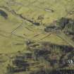
Stobs station is situated at the beginning of a deep cutting immediately S of Barns Viaduct (NT50NW 25.01), and off a minor road leading to Barns farmsteading.

The station consists of two platforms , one 'up' (to London) and a 'down' (to Edinburgh) along with a bay platform on the W side. The extant station building is in a 'baronial style' and situated on the down platform. A footbridge over the trackbed is still extant at the southern end of the platforms (NT 50522 09695).

The station is visible on several sorties of vertical air photographs, (RAF 1945-1950s), however, the most useful being the 1965 series (OS/65/4, 307-308, flown 29 March 1965).

The station opened as Barnes in 1862 as part of The North British Railway Border Union Railway, but was re-named that year to Stobs. The station closed in 1969.

Information from RCAHMS

The station and environs was visited by RCAHMS during May 2010 to undertake a phtographic survey as part of the Waverley Line Project. It should be noted that the station masters house is a private dwelling and the platforms, ticket office and footbridge all form part of the attached private property. The RCAHMS were kindly given permission by the owners to photograph the railway structures. Permissions to visit the site should be sought from the owners. The footbridge is in a dangerous condition and access across it should not be attempted.

Visited by RCAHMS (DE, AL), 19 May 2010

References

MyCanmore Image Contributions


Contribute an Image

MyCanmore Text Contributions