
Perth, Town Defences


Gateway(S) (Period Unassigned), Town Wall (Period Unassigned)
Site Name Perth, Town Defences
Classification Gateway(S) (Period Unassigned), Town Wall (Period Unassigned)
Canmore ID 28417
Site Number NO12SW 5
NGR NO 11 23
Datum OSGB36 - NGR
Permalink http://canmore.org.uk/site/28417


- Council Perth And Kinross
- Parish Perth
- Former Region Tayside
- Former District Perth And Kinross
- Former County Perthshire
NO12SW 5 11 23
For burgh and town of Perth, see NO12SW 100. For discovery of town ditch (at NO 118 235), see NO12SW 147.
Perth Town Walls and Later Defences.
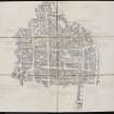
In 1311-12 Perth was a place of great strength fortified on three sides by a thick wall having stone towers at the angles and over the gates and surrounded by a wet ditch fed by a lade from the Almond (See Town's Lade - NO12SW 50) (S Cowan 1904 and R S Fittes 1881)
The southern part of the City Wall, along Canal Street, was demolished in 1766. (Information from M E C Stewart to OS, 9 January 1961)
There are no remains extant. (Visited by OS {J L D} 14 December 1960) Plans of the city as it was in 1715 (Information from 'An exact plan of ...Perth' 1715-16 and from 'A plan of Perth...' 1715-16 by L Petit) showed a line of fortification built by the Jacobite Rebels from the North Inch round the west side of the town to the citadel (NO12SW 22) and a small redoubt in the area of Blackfriars, Union and Kinnoull Streets erected by the townsmen.
S Cowan 1904; R S Fittes 1881.
NO 119 237 Excavations were carried out during May to June 1991 prior to re-development at 29-41 Skinnergate, which lay on the projected line of the existing nearby city wall.
Large clay bonded wall footings and revetments were revealed just above the present-day water table. Pottery and coin finds date these features to the 15th century, and so must surely represent at least one phase of construction of the city wall. Part of the Red Brig Port, known from documentary evidence to have been sited where Skinnergate bridged the lade, is almost certainly indicated by the clay bonded foundation courses butting the city wall.
Sponsors: SUAT, Perth and Kinross Heritage Trust.
C F Falconer 1991a; SUAT 1992.
NO 113 234 Observations of contractors' trenches and ground reduction at the former County Council premises in York Place failed to locate Jacobite defences thought to run through the N of this site.
R Cachart 1992.

