
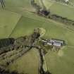
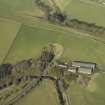
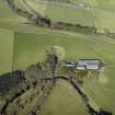
Bowshank, Farm Access Footbridge, Bridge No.76


Footbridge (Period Unassigned)
Site Name Bowshank, Farm Access Footbridge, Bridge No.76
Classification Footbridge (Period Unassigned)
Alternative Name(s) The Waverley Line; Edinburgh To Hawick Branch Railway
Canmore ID 283846
Site Number NT44SE 28.05
NGR NT 45405 41117
NGR Description From NT 45422 41125 to NT 45380 41103
Datum OSGB36 - NGR
Permalink http://canmore.org.uk/site/283846


- Council Scottish Borders, The
- Parish Stow
- Former Region Borders
- Former District Ettrick And Lauderdale
- Former County Midlothian
NT44SE 28.05 from 45422 41125 to 45380 41103
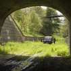
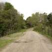
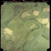
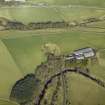
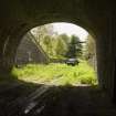
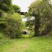
Footbridge providing access to Bowshank farm from the W built high over a deep railway cutting.
The bridge has tall brick piers and the decking is of wood. The structure has lost the hand rails.
The bridge is numbered No.76.
Due to be demolished when the railway is rebuilt.
Information from RCAHMS (DE), July 2006
Photographed in 2007 as part of a survey of Waverley Line remains in advance of proposed rebuilding of the railway and to enhance and augment the existing holdings of the National Monuments Record Scotland.
Information from RCAHMS (DE), April 2007

