
Ward


Building (Period Unassigned), Enclosure (Period Unassigned), Platform (Period Unassigned), Settlement (Period Unassigned), Track (Period Unassigned)
Site Name Ward
Classification Building (Period Unassigned), Enclosure (Period Unassigned), Platform (Period Unassigned), Settlement (Period Unassigned), Track (Period Unassigned)
Canmore ID 283561
Site Number NT13SW 90
NGR NT 140 344
Datum OSGB36 - NGR
Permalink http://canmore.org.uk/site/283561


- Council Scottish Borders, The
- Parish Drumelzier
- Former Region Borders
- Former District Tweeddale
- Former County Peebles-shire
NT13SW 90 NT 140 344
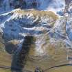
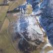
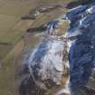
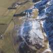
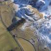
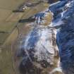
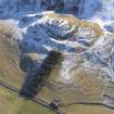
As part of the continuing re-survey of Tweeddale (DES 2000, 74-5) the following new site has been recorded.
NT 140 344 Enclosures, buildings, terraces, tracks and platforms. Probable post-medieval settlement and associated remains at Tinnis Castle, Drummelzier.
In total, 401 sites are listed in this survey, with illustrations and discussion. Full report at www.biggararchaeology.org.uk.
T Ward 2005.

