
Following the launch of trove.scot in February 2025 we are now planning the retiral of some of our webservices. Canmore will be switched off on 24th June 2025. Information about the closure can be found on the HES website: Retiral of HES web services | Historic Environment Scotland
Hilton House


Fort (Prehistoric), Plantation Dyke (19th Century), Quarry(S) (19th Century)
Site Name Hilton House
Classification Fort (Prehistoric), Plantation Dyke (19th Century), Quarry(S) (19th Century)
Alternative Name(s) The Roundel; Fir Knowe
Canmore ID 28352
Site Number NO12SW 189
NGR NO 11490 20106
Datum OSGB36 - NGR
Permalink http://canmore.org.uk/site/28352


- Council Perth And Kinross
- Parish Forgandenny
- Former Region Tayside
- Former District Perth And Kinross
- Former County Perthshire
NO12SW 189 11490 20106
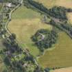
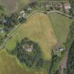
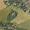
Air photography (John Dewar 1975; RCAHMSAP 1978, 1984 and 1989) has recorded the cropmarks of a fort on a spur at the foot of the SE flank of Hilton Hill. The summit of the spur is occupied by a modern house and its garden, and the steep natural slopes on the E, S and W are wooded. On the N, the easiest line of approach, the cropmarks of at least five concentric ditches can be seen on aerial photographs; the ditches, which measure up to 3m in breadth, are broken by a well-defined entrance on the NW, and the two outermost appear to terminate short of the wood on the NE.
At the date of visit it was not possible to obtain access to the wooded slopes of the spur, and it is not known whether any trace of the defences may be discerned on these parts of the circuit.
Visited by RCAHMS (JRS), 10 December 1997.
Watching Brief (26 January 2009 - 4 March 2009)
NO 1147 2010 A watching brief was maintained on 26–27 January and 2–4 March 2009 during the excavation of narrow trenches to accommodate cables around the N side of a 1950s bungalow. The house sits on a rock outcrop overlooking the lower reaches of Strathearn and is the site of a prehistoric or early historic fort, identified by aerial photographs, which show a series of five ditches in what is now a ploughed field to the N of the house.
The main trench, c80m long, ran along the N side of the base of the outcrop. Other, smaller trenches were located on the N and W sides of the mound. Three features of interest were uncovered in the main trench, two possibly remnants of the fort’s ditches and the third perhaps associated with a putative entrance on its NW side. Nothing of significance was found on the mound itself.
Archive and Report: Perth and Kinross SMR and RCAHMS
Funder: Scottish and Southern Energy plc
John Lewis – Scotia Archaeology
Watching Brief (March 2009)
An archaeological watching brief undertaken during the excavation of trenches for an 11kv underground cable to replace an overhead power line and for a new low voltage underground cable at the Roundel, Craigend, Perth. The refurbishment was carried out by Scottish & Southern Energy plc (SSE).
The watching brief was commissioned by Allan Coburn of SSE and undertaken by John Lewis of Scotia Archaeology on 26th and 27th January and 2nd and 4th March 2009.
Magnetometry (21 September 2012)
NO 1147 2010 A c21200m2 gradiometric survey was conducted, on 21 September 2012, across agricultural fields surrounding a wooded outcrop. The survey confirmed the presence of ditches initially identified by aerial photography in 1975. At least five, perhaps six, ditches were recorded to the NW of the Roundel. Towards the SE the line of these ditches became less clear within a zone dominated by the underlying igneous geology. The geophysical data suggest the three innermost ditches are different in character to the outer ones. Other features detected in the field related to the underlying geology and a well noted on the OS 1st Edition map of 1866.
Archive: University of Glasgow and RCAHMS (intended)
Funder: Historic Scotland and University of Glasgow
Tessa Poller, University of Glasgow
2012
Excavation (5 October 2013 - 19 October 2013)
NO 1147 2010 Two small excavation trenches were dug, 5–19 October 2013, to investigate the hillfort at The Roundel. Five ditches, initially recorded as cropmarks, were examined in a 43 x 2m trench on the N side of the hill. The lower fills in the second and third outer ditch contained what was interpreted to be turf and mixed subsoil. These fills were probably the remains of collapsed bank material. The upper fills of all the ditches were consistent and probably related to the final demolition of the banks during the Improvements. No traces of any of the banks associated with the ditches survived. A second trench placed to explore the terminal of the outer ditch recorded large boulders at its base, which may indicate a particular stone elaboration at the entrance.
Archive: University of Glasgow and RCAHMS (intended)
Funder: Historic Scotland and University of Glasgow
Tessa Poller, University of Glasgow, 2013
(Source: DES)
Note (8 May 2015 - 18 May 2016)
Cropmarks have revealed the presence of a fort encircling the hillock surmounted by Hilton House. At least five ditches are present on the NW, extending round onto the NE, but the rest of the hillock is clothed in woodland with a dense understorey. Geophysical survey has confirmed the presence of the ditches elsewhere (Poller 2012) and at least two of the ditches were located in a cable trench on the E (Lewis 2009); more recently traces of the two outermost ramparts on the SW have been recorded within the woodland, while a scarp 2m high on the SE is possibly a fragment of the inner rampart. The projection of the cropmarks, combined with this new survey, suggests that the fort encloses an oval area measuring about 70m from NW to SE by up to 50m transversely (0.27ha), though there may be a rather smaller inner enclosure on the summit. The cropmarks reveal a clear entrance on the NW, to the S of which there may have been a reduction in the number of ditches and ramparts, and there may be a second entrance on the E.
Information from An Atlas of Hillforts of Great Britain and Ireland – 18 May 2016. Atlas of Hillforts SC3040
Field Visit (6 October 2015)
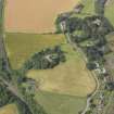
‘The Roundel’ is a rocky igneous knoll that projects from a point close to the foot of the SE flank of Kirkton Hill 1.3km south of Perth and 2km NW of Bridge of Earn. Survey of the remains of a fort there was undertaken in November 2015 by HES to reconcile the cropmarks of the defences (first recorded in 1975 and partly excavated in 2013) with the fragmentary upstanding remains of banks identified in woodland on the SW flank of the knoll by members of RCAHMS staff at the time of the excavation.
‘Fir Knowe’, as ‘The Roundel’ was then known, is depicted as a roughly oval area of mixed deciduous and coniferous woodland on the first edition of the OS 25-inch map (Perthshire 1866, Sheet XCVIII.13). This map shows an ‘Old Quarry’ on the east side of the knoll and a wall, most likely a plantation boundary, which ran from that quarry, around the northern edge of the woodland to a point on the NW flank where it terminated. These features are still visible though the wall is now ruinous and reduced in places to little more than a stony bank. In the early 1960s the summit of the knoll was chosen as the site of a dwelling and the present owner (Mr Douglas Johnson) informed JRS that at that time there was only a thin cover of soil present and that the foundations of the house had to be excavated into solid rock. Moreover, in order for a garden to be created a huge amount of soil was transported from a development site in Glenearn Road, Perth, over the course of a whole winter. This information helps explain the uppermost scarp which forms the edge of the garden and which gives every indication of being a landscaped feature created by earthmoving machinery. On the NE, the relationship of the slopes suggests that the formation of the platform on which the garage was built may have been a secondary consideration -- though not one that was necessarily separated from the principal earthmoving event by very much time. There are no contemporary reports of any artefacts or structures being found during the course of the building of the house and its garden.
The cropmark evidence indicates that there were originally at least five lines of defence in what is now arable ground immediately to the NE and NW (where there is an entrance) of the knoll. On the wooded NE flank of the knoll itself, where it might have been expected that there would be surviving traces of banks, no visible remains have been identified. However, much of this ground has been disturbed or obscured by the 1960s landscaping, the dumping of field cleared stones or the construction and subsequent collapse of the plantation wall. Original earthworks have almost certainly also been destroyed by quarrying and other episodes of digging.
Two scarps on the SW flank of the hill , the lowermost about 47m in length, appear to represent the continuation of the banks that would have originally accompanied the two outermost cropmark ditches on the NW. The purpose of two other, shorter, scarps further up the slope is less clear, but they, too, may be the remains of original banks.
At the SE end of the knoll there are two scarps, the inner situated below the landscaped edge of the garden and measuring at least 2m in height. Largely obscured by vegetation, including dense brambles, on the date of visit, the north end of this scarp appears to run out from under the landscaped feature and extend south and then west for a distance of at least 35m before disappearing again under it. On the south this scarp is accompanied by another, the east end of which seems to have been destroyed by the construction of the platform on which a brick-and-timber hen-house has been built.
The degree to which the fort on The Roundel has been disturbed since the early 19th century makes it very difficult to assess its original internal size. The dumping of large quantities of soil and the creation of the garden has obscured the natural topography to such an extent that it is not now possible to judge the obvious line which the inner rampart or wall might have followed. And survey of other relatively small multi-vallate forts nearby (for instance Jackschairs Wood; NO01NE 20) has shown that it is not safe to assume that lines of defence need necessarily follow the contours of the knoll on which they are situated. Further, the lack of any visible evidence of defence on a steep slope, for instance the southern flank of The Roundel, cannot be interpreted as evidence that there were no defences here. Given the available evidence, it is likely that the fort was roughly oval on plan and its internal dimensions were about 70m from NW to SE by up to 50m transversely, thus corresponding fairly closely with the size of the fort in Jackchairs Wood.
Visited by HES Survey and Recording (JRS, AM), 6 November 2015.
Measured Survey (6 October 2015)
HES surveyed Hilton House fort between 3-6 October 2015 with plane-table and self-reducing alidade at a scale of 1:500. GNSS was used to record survey control. The resultant plan was redrawn in vector graphics software.

