
Pricing Change
New pricing for orders of material from this site will come into place shortly. Charges for supply of digital images, digitisation on demand, prints and licensing will be altered.
Benbecula, Cnoc Sornain


Mound (Period Unassigned)
Site Name Benbecula, Cnoc Sornain
Classification Mound (Period Unassigned)
Canmore ID 283496
Site Number NF75NE 17
NGR NF 7759 5540
Datum OSGB36 - NGR
Permalink http://canmore.org.uk/site/283496


- Council Western Isles
- Parish South Uist
- Former Region Western Isles Islands Area
- Former District Western Isles
- Former County Inverness-shire
NF75NE 17 NF 7759 5540
Survey - A coastal zone assessment survey was carried out over the islands of Grimsay, Benbecula and the W coast of South Uist. A total of 200 sites of all dates and types were recorded, 175 of which were recorded for the first time. Some of the more significant findings include:
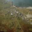
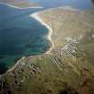
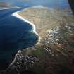
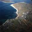
NF 7759 5540 Cnoc Sornain. Large mound on the coast edge; cut into the sea, exposing a 120m long section containing stonework and anthropogenic deposits.
Full report available online at www.scapetrust.org.
Sponsor: SCAPE Trust.
H Moore and G Wilson 2005
Field Visit (2005)
BB 64. A large mound situated on the coast edge has been cut into by the sea. The mound measures some 90m E-W by 70m N-S. It was probably originally circular in plan, but up to 10m of the seaward side has been lost to coastal erosion. Part of the SW side of the mound is likely to have been damaged when the present road was built, and subsequently at each new improvement of the road. A section, measuring some 120m long is now exposed. Prior to damage caused during the recent storms, anthropogenic deposits, together with traces of possible stonework, were noted in this exposure. These remains were not visible at the time of this survey due to the presence of slumped turf and accumulated sand.(Information supplied by R. McCullagh).
Moore and Wilson 2005, 245

