Accessibility

Font Size

100% 150% 200%

Background Colour

Default Contrast
Close Reset

Unst, Saxa Vord, Royal Air Force (Raf) Saxa Vord

Radar Station (20th Century)

Site Name Unst, Saxa Vord, Royal Air Force (Raf) Saxa Vord

Classification Radar Station (20th Century)

Alternative Name(s) 91 Signals Unit; Little Foulstanes

Canmore ID 282548

Site Number HP61NW 6.04

NGR HP 62980 16590

NGR Description Centred HP 62980 16590

Datum OSGB36 - NGR

Permalink http://canmore.org.uk/site/282548

Ordnance Survey licence number AC0000807262. All rights reserved.
Canmore Disclaimer. © Bluesky International Limited 2025. Public Sector Viewing Terms

Toggle Aerial | View on large map

Digital Images

Oblique aerial view of Saxa Vord, Unst, looking S.
Oblique aerial view of Saxa Vord, Unst, looking S.Oblique aerial view of Saxa Vord, Unst, looking SW.Oblique aerial view.Oblique aerial view of Saxa Vord, Unst, looking S.Oblique aerial view of Saxa Vord, Unst, looking W.General oblique aerial view of Saxa Vord RAF Radar Station, Unst, looking S.General oblique aerial view of Saxa Vord RAF Radar Station, Unst, looking SE.Oblique aerial view of Saxa Vord, Unst, looking SSW.Oblique aerial view of Saxa Vord, Unst, looking WSW.Oblique aerial view.Oblique aerial view.General oblique aerial view of Saxa Vord RAF Radar Station, Unst, looking SE.Oblique aerial view of Saxa Vord, Unst, looking SW.Oblique aerial view of Saxa Vord, Unst, looking SW.Oblique aerial view of the Saxa Vord radar station and the cairns, looking E.Oblique aerial view of the Saxa Vord radar station and the cairns, looking ENE.Oblique aerial view of Saxa Vord, Unst, looking NW.Oblique aerial view of Saxa Vord, Unst, looking WSW.Oblique aerial view.Oblique aerial view.Oblique aerial view of the Saxa Vord radar station and the cairns, looking ENE.General oblique aerial view of Saxa Vord RAF Radar Station, Unst, looking S.Oblique aerial view of Saxa Vord, Unst, looking SSW.Oblique aerial view of Saxa Vord, Unst, looking W.

Administrative Areas

  • Council Shetland Islands
  • Parish Unst
  • Former Region Shetland Islands Area
  • Former District Shetland
  • Former County Shetland

Archaeology Notes

HP61NW 6.04 centred 62980 16590

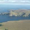
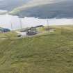
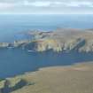
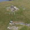
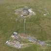
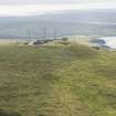
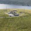
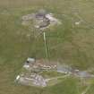
Postwar NATO early warning station covering 7.14 hectares built on the summit of Saxa Vord.

Four masts and several, buildings are depicted on the current OS 1:2500 scale digital map.

Opened in 1955 and subsequently upgraded several times. In 2005 the type 93 radar was dismantled and removed

and the Station closed 1 March 2006.

Information from RCAHMS (DE), September 2006

References

MyCanmore Image Contributions


Contribute an Image

MyCanmore Text Contributions