
Perth, General


Burgh (Medieval), Town (Period Unassigned)
Site Name Perth, General
Classification Burgh (Medieval), Town (Period Unassigned)
Canmore ID 28254
Site Number NO12SW 100
NGR NO 1168 2347
Datum OSGB36 - NGR
Permalink http://canmore.org.uk/site/28254


First 100 images shown. See the Collections panel (below) for a link to all digital images.
- Council Perth And Kinross
- Parish Perth
- Former Region Tayside
- Former District Perth And Kinross
- Former County Perthshire
NO12SW 100 11 23.
For Kinnoull burgh, see NO12SW 209.
For possible evidence of pre-burghal activity, see NO12SW 241.
For Perth town defences, see NO12SW 5 and NO12SW 147. For Perth castle (NO 1187 2381) and South Inch, Cromwellian Citadel (NO 1200 2306), see NO12SW 28 and NO12SW 22 respectively. For town water supply, see NO02NE 4 and NO12SW 50.
For 102-6 High St, Guildhall and 2-26 High St, Municipal Buildings, see NO12SW 218 and NO12SW 323 respectively. For High Street (Kirkgate/Skinnergate), Market Cross (NO 1195 2363), see NO12SW 150. For tolbooth (NO c. 1207 2366), see NO12SW 125 and NO12SW 340.
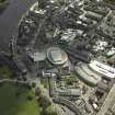
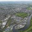
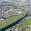
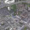
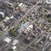
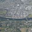
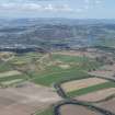
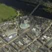
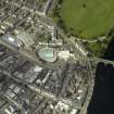
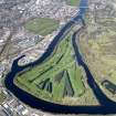
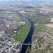
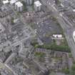
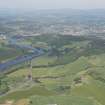
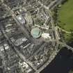
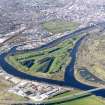
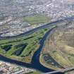
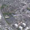
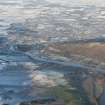
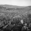
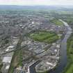
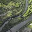
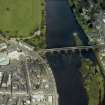
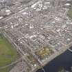
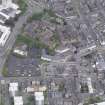
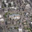
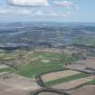
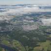
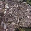
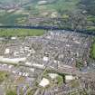
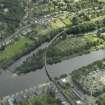
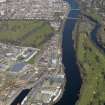
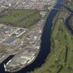
The burgh of Perth is situated on the right bank of the River Tay at the highest point of tidal navigation and at an easy fording-point, 32.5km W of Dundee (NO43SW 76) and 76km N of Edinburgh (NT27SW 26). Its hinterland is rich agricultural land and the city is on a major NE-SW trade route.
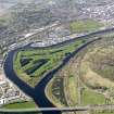
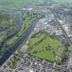
The city is situated on a gentle plain rising a few metres above the level of the river, and is bounded at each end by the meadows that form the insular North and South Inches respectively. The Rivers Almond and Earn enter the Tay to the N and S respectively of the city.
The place-name 'Perth' may refer to the well-wooded hills around, and the name St John's Town or St Johnstoun has been applied since the 13th century. The town is on record as a burgh of David I (1128-53) and there is a surviving charter of William the Lion (1165-1214). The burgh apparently supplanted Scone (NO12NW 9.13) as a place of royal resort from the 12th century onwards and was represented in parliament as early as the mid 14th century, although it was never formally the capital of Scotland.
The earliest building in Perth to receive specific mention is the Dominican Friary (NO12SW 6) in which the Treaty of Perth (1266) was signed between kings Alexander III of Scotland and Magnus IV of Norway. The friary church was also the venue of a General Council in 1365, while James I held both a General Council and a Parliament in Perth, in 1427 and 1429 respectively, after which James II apparently held parliaments in the Tolbooth (NO12SW 340). One of the first conventions of royal burghs was held at Perth in 1555 and the church of the 'reformed religion' convened General Assemblies at Perth in 1563, 1597 and 1618.
Perth played an active role (on the Presbyterian side) in the Civil Wars of the 1640's but the victory of Montrose at the battle of Tippermuir or Tibbermore (1644) resulted in a period of Royalist occupation until the town was captured by Cromwell's army, who maintained their hold by the construction of a citadel (NO12SW 22). The town was again strengthened and re-fortified by the Jacobites in 1715 and 1745.
Throughout the medieval period, Perth traded in the basic commodities of hides, cloth, timber and wool, the wool trade to the Low Countries being particularly important while the timber trade was based on logs floated downstream. The textile industry was also important, and developed rapidly) particularly in linen, in the 18th century.
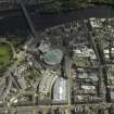
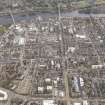
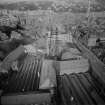
The physical layout of Perth is determined by the nature of its site, and is centred accordingly on the wharf and the Watergate; it remained strikingly compact until its rapid expansion in the late 18th and early 19th centuries. The original burgh axis was probably N-S (on the line of Kirkgate and Castle Gate/Skinnergate) with the church (NO12SW 41.00) at the S and the castle (NO12SW 28) at the N. The axis was radically altered to E-W, apparently before the end of the 18th century, allowing for a more generous layout along the line of South St and High St. Many new streets were laid out, the town defences (NO12SW 5) were demolished, and the hamlet of Bridgend (centred NO 122 242) became more important in the late 18th century.
The first reference to a bridge in Perth was in 1209 when the structure (NO12SW 77) is said to have been destroyed by flood; it was evidently replaced by 1214 and is recorded as needing repair on numerous subsequent occasions. A new bridge was built in 1617 but destroyed by flood in 1621; further attempts to replace it proved unsuccessful until Smeaton's bridge (NO12SW 149) was built in 1766.
A T Simpson and S Stevenson 1982.
NMRS PRINT ROOM
W Schomberg Scott Photograph Collection Acc No 1997/39
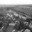
Postcard published by the Friends of St John's Kirk of Perth, view from Rhynd Road looking North-West.
NMRS REFERENCE
Board of Ordnance Drawings
In the National Library of Scotland is a series of Military Maps and Drawings (many coloured) of the Board of Ordnance, and relating to the Works carried out in the 18th Century. Reference (MSS. 1645-1652).
Those relating to perth are contained in Volume or Case No. 1648 and are as follows:-
Number. Year.
Z.3/2 1715/6 "An Exact Plan of the Town and adjacent parts of Perth, as it was Fortified and Possess'd by the Rebells in Scotland till they were driven thence, by the Victorious Arms of King George. Anno 1715/6." With Reference. Scale 100 Geometrical Paces to an Inch. This Shews the Old Fort "built by Cromwell". There are 2 copies.
Z.3/1 1715/6 "A Plan of Perth with the Retrenchment made about it by the Pretenders Engineers". 1715/6. Scale set down as 200 Feet to an Inch. Signed by Lewis Petit. Shews the Old Fort in ruin.
" N.D. Two copies of "Plan of Perth and adjacent Places with projection of a (proposed) Cittadel, by Brigr. Petite. Scale set down as 500 Feet to an Inch.
Z.3/1 1745/6 A small plan of "An ancient piece of Fortification near Perth lately repaired by the Rebels". Scale about 100 Feet to an Inch. Drawn and surveyed by Jas. Leigh Jones. Date is Feb. 9th year seemingly 1745/6.
Z.3/3 1723 "Plan of the King's House and Garden at Perth" with explanation and John Romer's Report relating thereto and regarding proposal to fit up for the quartering of Troops. Signed London, Feb. 11, 1723 by J. Romer, Engineer.
Z.3/4 1754 "Plan of the Train Barracks at Perth, formerly the house of Earl Gowry, 1754". With Explanation. Scale 20 Feet to an Inch. Surveyed by Chas. Tarrant. There is also a copy. This is what is called the King's House on Z.2/3 above, and gives detailed plans, sections and elevations.
Perth.
Map of,
Part of the Barracks.
The National Library of Scotland, Edinburgh, contains, among the "Uncatalogued MSS of general Hutton", and numbered 115, 117 and 118, in Vol.I, two copies of a Plan of Perth to the scale of 400 feet to 1 inch; an engraved view of the South-East prospect taken from the Wood end, by Alexander Robertson (No date given); and a pencil Sketch, dated 1783, of part of the Barracks at Perth.
External Reference
Perth, Glenorchy House. Exact location unknown at time of upgrade, 23.2.2000.
SRO
Repair of Lord Glenorchy's House in Perth. Letters from Viscount Stormont to Sir Colin Campbell. He describes the house as ruinous and the #80 Lord Glenorchy has offered, quite insufficient to repair it.
1635 GD 112/39/579 and 581
The condition of Glenorchy's house is described as ruinous. The Viscount of Stormont wishes Glenorchy to have it repaired.
1635 GD 112/39/479
repairs to Glenorchy House, Perth. Accounts.
1573-1598 Gd 112/20/5
NMRS REFERENCE
Perth, Good Templar Hall
Architect: James Smart 1894-5
Exact location unknown at time of upgrade.
Perth, Monument to Rev Wm Wilson, First Secession Minister, Perth.
Exact location missing at time of upgrade, 23.3.2000.
Print (Magnus Jackson Collection) missing at time of upgrade, 23.3.2000.
Perth, Royal Bank of Scotland, Architect: David Smart 1899
Exact location unknown at time of upgrade, 23.3.2000.
Perth, St Andrew's Episcopal School & Chapel.
J Peacock Architect 1869
Never carried out.
"Scrap Book" 1 engraving. Missing at time of upgrade, 30.3.2000.
Perth, Queen Victoria Triumphal Arch
Architect: W.M. Mackenzie Lithograph
Missing at time of upgrade, 30.3.2000.
Perth, St Martins Church.
Architect: Andrew Heiton Snr 1843
Location unknown at time of upgrade, 30.3.2000.
Perth, 90th Light Infantry Memorial.
Architect: Robert Lorimer
Location unknown at time of upgrade, 5.5.2000.
4 schemes for memorial
Perth, Toll House, A.9, which was unlocated at time of ACP in January 2005, was demolished in November 1967. Information from Demolitions catalogue held in RCAHMS Library.

