
Dalbeattie, Royal Naval Armaments Depot, Nitro-glycerine Works, Unit 1


Building(S) (20th Century), Fire Station (20th Century), Hut(S) (20th Century), Magazine(S) (20th Century), Structure(S) (20th Century)
Site Name Dalbeattie, Royal Naval Armaments Depot, Nitro-glycerine Works, Unit 1
Classification Building(S) (20th Century), Fire Station (20th Century), Hut(S) (20th Century), Magazine(S) (20th Century), Structure(S) (20th Century)
Alternative Name(s) Edingham Industrial Estate; Kirkgunzeon Lane; Edingham Munitions Factory
Canmore ID 282399
Site Number NX86SW 36.04
NGR NX 8495 6325
NGR Description Centred NX 8495 6325
Datum OSGB36 - NGR
Permalink http://canmore.org.uk/site/282399


First 100 images shown. See the Collections panel (below) for a link to all digital images.
- Council Dumfries And Galloway
- Parish Kirkgunzeon
- Former Region Dumfries And Galloway
- Former District Stewartry
- Former County Kirkcudbrightshire
NX86SW 36.04 centred 8495 6325
Falls partly on map sheet NX86SE
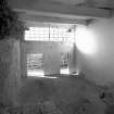
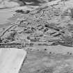
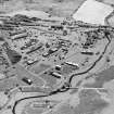
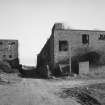
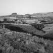
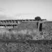
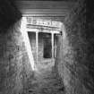
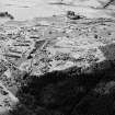
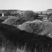
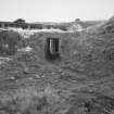
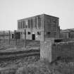
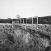
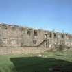
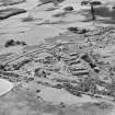
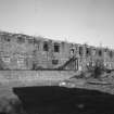
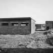
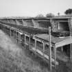
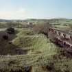
The area to the N of the Kirkgunzeon Lane burn is known as Unit 1, the area is situated to the N and E of Kirkgunzeon Lane. Within the area are the upstanding remains of most of the processing houses for nitro-glycerine production. The following buildings can be found within the area: Acid Plant, Acetone Plant, Incorporation Houses, Processing Houses, Starting and Acetone Recovery Houses, magazines, Gun Cotton unloading and general goods station, Gun-cotton expanse magazines, Drying and Blending Houses, Cordite milling, Fire Station, Air-raid shelters, Boiler House and a large canteen.
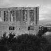
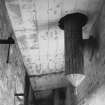
Most of the buildings are of brick and concrete, with brick the predominant material. Of particular note is the brick and concrete Acetone Tower (NX 85014 63100), which is situated adjacent to the large canteen building (NX 85021 63081). On the ground floor are three concrete circular bases, two of which measure 1.26m in diameter and one 2.02m in diameter. What may have been a sump on the SW side of the circular bases extends the full width of the building. The building has a flat concrete roof and the upper floors would have been supported on steel RSG beams, these have now been removed and on the SW side an external stairway led to a hoist. Windows are metal framed and there is a doorway on the first floor with a small platform landing extending the whole width of the building. What may be a drain leads away from the building to the N.
In association with the Acetone Tower are two Acetone Recovery Houses situated 177m WNW and 270m NW of the tower, one of single width (NX 84838 63121) the other a double width building (NX 84821 63279) respectively. Evidence from the RAF WW II (No.1 CAM oblique, 1941 and 1942), air photographs would suggest that one was built later than the other.
The internal layout of the Processing Houses is also of interest. There are two platforms with steps leading up to them each side of a square well, now usually filled with water, with doors at the back leading to a rear corridor. The steps and platformshave been coated with a rubber composition to reduce the danger from sparks. The height of the platform is 1.15m and they measure 2.70m by 1.70m with a recess in the vertical face of 50cm by 50cm. Evidence of other equipment can be seen on the wall, the marks and fixing holes providing the location of whatever this may have been.
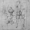
Within many of the Acetone Recovery and Incorporation Houses on the whitewashed walls are contemporary and later pencil graffiti. Much of the graffiti takes the form of poems and drawings of various subjects along with names and dates. The dates range from the 1940s up to the 1980s and more recent. It has to be assumed that much of the writing and grafitti was generated by those that worked within the various buildings, though some of the later material is by 'visitors' to the site.
The site was rail connected and traces of the sidings are still discernable on the E side of the area. The internal tramway system linked this area with all other parts of the site.
The range of buildings contained within the Unit 1 area provides a good impression of what was involved in the production of explosives. Many of the buildings are presently used by the local farmer to house cattle and there is still a military connection in that the army continues, from time to time, to use the area for urban warfare training.
Visited by RCAHMS (DE, GL), 25 September 2006

