
Blairhall


Barrow(S) (Prehistoric), Pit(S) (Period Unknown)
Site Name Blairhall
Classification Barrow(S) (Prehistoric), Pit(S) (Period Unknown)
Canmore ID 28162
Site Number NO12NW 32
NGR NO 11638 28102
Datum OSGB36 - NGR
Permalink http://canmore.org.uk/site/28162


- Council Perth And Kinross
- Parish Scone
- Former Region Tayside
- Former District Perth And Kinross
- Former County Perthshire
Aerial Photographic Transcription (23 November 1989 - 15 February 1994)
An aerial transcription was produced from oblique aerial photographs. Information from Historic Environment Scotland (BM) 31 March 2017.
Aerial Photographic Interpretation (14 December 1992)
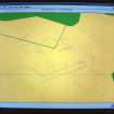
NO12NW 32 Centred on NO 11638 28102
Aerial photography has revealed two barrows set on opposite sides of the cursus NO12NW 43; the ditches of the barrows and the cursus intersect, but the relationship between them is uncertain. Several other possible ring-ditches, together with numerous pits and linear features, are visible in the field, one of the ring-ditches lying within the cursus.
Information from RCAHMS (JRS) 14 December 1992.

