
Pricing Change
New pricing for orders of material from this site will come into place shortly. Charges for supply of digital images, digitisation on demand, prints and licensing will be altered.
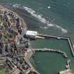
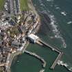
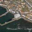
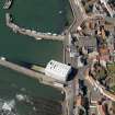
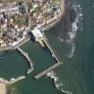
St Monance Harbour, Detached East Breakwater


Breakwater (Period Unassigned)
Site Name St Monance Harbour, Detached East Breakwater
Classification Breakwater (Period Unassigned)
Alternative Name(s) St Monans Harbour
Canmore ID 281088
Site Number NO50SW 81.06
NGR NO 52701 01493
NGR Description NO 52701 01493 to NO 52750 01514
Datum OSGB36 - NGR
Permalink http://canmore.org.uk/site/281088


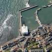
- Council Fife
- Parish St Monance
- Former Region Fife
- Former District North East Fife
- Former County Fife

