Accessibility

Font Size

100% 150% 200%

Background Colour

Default Contrast
Close Reset

Crail Harbour, Slipway

Slipway (Period Unassigned)

Site Name Crail Harbour, Slipway

Classification Slipway (Period Unassigned)

Canmore ID 280735

Site Number NO60NW 31.05

NGR NO 61211 07367

Datum OSGB36 - NGR

Permalink http://canmore.org.uk/site/280735
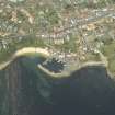
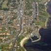
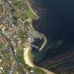
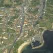
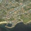
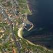
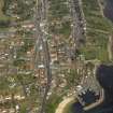
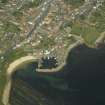
Ordnance Survey licence number AC0000807262. All rights reserved.
Canmore Disclaimer. © Bluesky International Limited 2025. Public Sector Viewing Terms

Toggle Aerial | View on large map

Digital Images

General oblique aerial view of the town centred on the harbour, taken from the SE.
General oblique aerial view of the town centred on the harbour, taken from the SE.General oblique aerial view of the town centred on the harbour, taken from the SSW.General oblique aerial view of the town centred on the harbour, taken from the WSW.General oblique aerial view of the town centred on the harbour, taken from the SSW.General oblique aerial view of the town centred on the harbour, taken from the SSE.General oblique aerial view of the town centred on the harbour, taken from the SW.General oblique aerial view of the town with the harbour in the foreground, taken from the SW.General oblique aerial view of the town centred on the harbour, taken from the S.

Collections

Administrative Areas

  • Council Fife
  • Parish Crail
  • Former Region Fife
  • Former District North East Fife
  • Former County Fife

Archaeology Notes

NO60NW 31.05 61211 07367

Slipway [NAT]

OS (GIS) AIB, April 2006.

References

MyCanmore Image Contributions


Contribute an Image

MyCanmore Text Contributions