
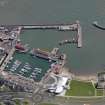
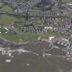
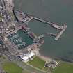
Arbroath Harbour, Wet Dock


Dock (Period Unassigned)
Site Name Arbroath Harbour, Wet Dock
Classification Dock (Period Unassigned)
Alternative Name(s) Arbroath, Inner Harbour
Canmore ID 280519
Site Number NO64SW 28.06
NGR NO 64214 40579
Datum OSGB36 - NGR
Permalink http://canmore.org.uk/site/280519


- Council Angus
- Parish Arbroath And St Vigeans
- Former Region Tayside
- Former District Angus
- Former County Angus
NO64SW 28.06 64214 40579
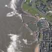
For footbridge (and possible mitred gates) at the entrance to this dock, see NO64SW 28.08.
Dock [NAT]
OS 1:10,000 map, 1986.
Wet Dock [NAT]
OS (GIS) AIB, April 2006.

