
Following the launch of trove.scot in February 2025 we are now planning the retiral of some of our webservices. Canmore will be switched off on 24th June 2025. Information about the closure can be found on the HES website: Retiral of HES web services | Historic Environment Scotland
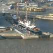
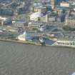
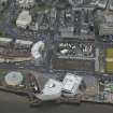
Dundee, Riverside Drive, Discovery Point


Museum (19th Century) - (20th Century), Visitor Centre (Modern)
Site Name Dundee, Riverside Drive, Discovery Point
Classification Museum (19th Century) - (20th Century), Visitor Centre (Modern)
Alternative Name(s) Dundee Harbour; Port Of Dundee; River Tay; Firth Of Tay; Rrs Discovery; Discovery Quay
Canmore ID 280499
Site Number NO42NW 186
NGR NO 40394 29812
Datum OSGB36 - NGR
Permalink http://canmore.org.uk/site/280499


- Council Dundee, City Of
- Parish Dundee (Dundee, City Of)
- Former Region Tayside
- Former District City Of Dundee
- Former County Angus
NO42NW 186.00 40394 29812
Discovery Point (Museum & Visitors Centre) [NAT]
OS (GIS) AIB, 18 April 2006.
NO42NW 186.01 NO 40445 29796 Slipway
For general summary of Dundee Harbour and the Port of Dundee, see NO43SW 109.
Discovery Quay: 1993, Michael Laird Partnership.
C McKean and D Walker 1984.

