
Pricing Change
New pricing for orders of material from this site will come into place shortly. Charges for supply of digital images, digitisation on demand, prints and licensing will be altered.
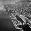
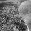
Dundee, Dock Street, King William Iv Dock, West Graving Dock


Dry Dock (Period Unassigned)
Site Name Dundee, Dock Street, King William Iv Dock, West Graving Dock
Classification Dry Dock (Period Unassigned)
Alternative Name(s) Port Of Dundee; Dundee Harbour; River Tay; Firth Of Tay
Canmore ID 280495
Site Number NO43SW 1002.03
NGR NO 40743 30201
Datum OSGB36 - NGR
Permalink http://canmore.org.uk/site/280495


- Council Dundee, City Of
- Parish Dundee (Dundee, City Of)
- Former Region Tayside
- Former District City Of Dundee
- Former County Angus
NO43SW 1002.03 40743 30201
For trial excavation and watching brief (Apex Hotel Development: 2001) at cited location NO 4075 3020, see NO43SW 1002.05.
The location assigned to this record remains unverified from current map evidence, within an area of car parks and urban redevelopment. Is noted and depicted in detail by GIS historic mapping (epoch 2).
Information from RCAHMS (RJCM), 18 April 2006.
Archaeological Evaluation (1997 - 2001)
Trial trenching by Ove Arup in 1997 and by SUAT in August 2001, followed by a watching brief in December 2001, revealed that the upper structure of the West Graving Dock (built 1815-23 to the design of Thomas Telford) survives largely intact, at a depth of 0.35 - 0.5m below the present ground surface. The dock was infilled during the construction of the Tay Road Bridge in the 1960s.
NO 407 302 A rapid walkover survey was undertaken in June 2001 on the development area for a proposed hotel next to the Customs House within the confines of Dundee Docks. The development area had no visible features associated with the King William IV Dock, the West Graving Dock, or any of the warehouses and other attendant features that used to occupy this area. An archaeological evaluation in August 2001 located the buried remains of the 19th-century West Graving Dock, which were in good condition. The E end of the dock was identified close to the surface, partially under the footprint of the hotel itself.
Sponsor:
Apex Hotels Ltd.
M Roy 2002
Watching Brief (December 2001)
In December 2001 an archaeological watching brief was undertaken over the remains of the West Graving Dock. The upper structure of the dock was identified at 0.35-0.50m below the modern ground surface and was generally covered by recent overburden. The dock was constructed from sandstone blocks bonded with coarse lime mortar. A stone drain was visible running behind the upper dock structure to the SE. This feature had also been identified in the earlier evaluation work, both to the E and N of the graving dock.
Archive to be deposited in the NMRS.
The foundations of the new build of the hotel were to be piled with interconnecting ring beams. This required the digging of the trenches to facilitate the insertion of the piles and the ring beams. The excavation of these trenches over remains of the West Graving Dock in Dundee's City Quay necessitated an archaeological watching brief in order to record any structures that might be disturbed.
The graving dock was encountered in all the … areas of trenching. The upper structure of the dock was visible at a shallow depth (0.35-0.5m) under the existing ground surface and was generally covered by overburden. All the dock structures consisted of sandstone blocks bonded with coarse lime mortar. The location of the upper step… in Trench 3 suggested that the graving dock continued at least a metre further east than was suggested by the earlier evaluation. Various deposits infilled and overlay the structures, including cinders and grave in Trench 1, and deposits rich in mortar, sandy silt and rubble elsewhere. A stone drain was visible running behind the upper dock structure in Trench 2, to the south-east. This feature had also been identified in the earlier evaluation work, both to the east and north of the graving dock. An apparent north-west to south-east running wall base … was also identified in this trench. This might also have been part of an upper step…
In general the piling work only affected structures less than 0.8m beneath the existing ground surface, and caused localised damage to only the uppermost part of the dock structure. This included the removal of the top step in a number of trenches, and of a possible sandstone and mortar wall in Trench 2
Information from SUAT
Trial Trench (June 2001)
Following a desk-based assessment, an archaeological survey was undertaken by SUAT Ltd in June 2001 of a proposed housing development at the eastern end of City Quay. Various features of the 19th century docks were recorded; road surfaces, warehouse foundations, a slipway and a railway track.
In order to accurately locate the buried structure of the West Graving Dock in relation to existing features in the immediate area, a short programme of trial trenching was undertaken. The edges of the dock thus located and recorded enabled the extrapolation of the position of the rest of the structure. This information will be of importance when it comes to providing an interpretation of the graving dock within the development area.
The walls of the graving dock were encountered in all five trenches. In two trenches (1 and 4) it appears likely that the main section of the dock wall has been truncated. Where this wall was undisturbed, however, it was around 0.9m wide and lay just 0.4-0.5m below the existing ground surface. The top of this wall stood around 3.77m OD. Steps leading down from this wall were around 0.3m - 0.4m deep, the top of the first step down standing ar around 3.45m OD. A stone drain was visible running behind the dock walls to the east and north. The lack of this feature in Trenches 1 and 4 was probably due to the limited size of the trenches, and it is very possible that this drain continued around the dock. Behind the main dock wall in Trench 3 stood a secondary, external wall. This was not encountered in Trenches 2 or 5 and it seems likely that this feature lay along the east side of the dock only, as the other trenches were long enough for it to have been reached. It may have formed a channel, at least 0.6m deep behind the dock. The infilling and levelling deposits over the development area were revealed; the main infilling deposits of the dock were remarkable merely for the large amount of sandstone masonry within them.
Information from SUAT,
Archaeological Evaluation: Apex Hotel Development, City Quay, Dundee.

