
Pricing Change
New pricing for orders of material from this site will come into place shortly. Charges for supply of digital images, digitisation on demand, prints and licensing will be altered.
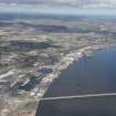
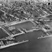
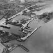
Dundee, Tidal Harbour


Dock (Period Unassigned)
Site Name Dundee, Tidal Harbour
Classification Dock (Period Unassigned)
Alternative Name(s) Port Of Dundee; Dundee Harbour; River Tay; Firth Of Tay; H.m. Submarine Base, Hms Ambrose
Canmore ID 280488
Site Number NO43SW 1001
NGR NO 40691 30065
NGR Description Centred NO 40691 30065
Datum OSGB36 - NGR
Permalink http://canmore.org.uk/site/280488


- Council Dundee, City Of
- Parish Dundee (Dundee, City Of)
- Former Region Tayside
- Former District City Of Dundee
- Former County Angus
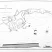
NO43SW 1001.00 centred 40691 30065
Extends onto map sheet NO42NW.
NO43SW 1001.01 NO 40804 30116 Swing Bridge
NO43SW 1001.02 NO 40810 30147 Patent Slip
NO43SW 1001.03 NO 40744 30142 Careening Beach
See also:
NO43SW 515 Centred NO 40481 30026 Earl Grey Dock
NO43SW 1002.00 Centred NO 40604 30182 King William IV Dock
For comprehensive history of early docks at Dundee, see under NO42NW 22.00.
For general summary of Dundee Harbour and the Port of Dundee, see NO43SW 109.
The Tidal Harbour at Dundee formed part of the docks complex to the W of the N end of the present Tay Road Bridge (NO42NW 75). An unlocked basin, it gave access to both Earl Grey Dock (NO43SW 515, to the W) and King William IV Dock (NO43SW 1002.00, to the N). It is noted and depicted by GIS historic mapping (epoch 2).
The location assigned to this record remains unverified from current map evidence within an area of car parks and urban redevelopment.
Information from RCAHMS (RJCM), 18 April 2006.

