
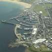
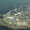
Fraserburgh Harbour, South Breakwater


Breakwater (Period Unassigned)
Site Name Fraserburgh Harbour, South Breakwater
Classification Breakwater (Period Unassigned)
Canmore ID 280447
Site Number NK06NW 3.29
NGR NK 00294 66847
NGR Description NK 00294 66847 to NK c. 00143 66702
Datum OSGB36 - NGR
Permalink http://canmore.org.uk/site/280447


- Council Aberdeenshire
- Parish Fraserburgh
- Former Region Grampian
- Former District Banff And Buchan
- Former County Aberdeenshire

