
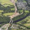
Fochabers, New Spey Bridge


Road Bridge (Period Unassigned)
Site Name Fochabers, New Spey Bridge
Classification Road Bridge (Period Unassigned)
Alternative Name(s) River Spey
Canmore ID 280261
Site Number NJ35NW 244
NGR NJ 34025 59483
Datum OSGB36 - NGR
Permalink http://canmore.org.uk/site/280261


- Council Moray
- Parish Speymouth
- Former Region Grampian
- Former District Moray
- Former County Morayshire
NJ35NW 244 34025 59483
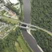
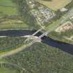
For predecessor bridge (adjacent to SW), see NJ35NW 24.00.
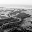
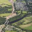
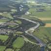
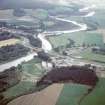
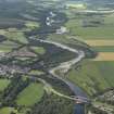
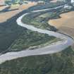
This bridge carries the present line of the A96 (T) public road over the River Spey on the western outskirts of Fochabers (NJ35NW 23). The river here forms the boundary between the parishes of Bellie (to the E) and Speymouth (to the W).
The location assigned to this record defines the apparent midpoint of the structure. The available map evidence indicates that it extends from NJ c. 34005 59504 to NJ c. 34083 59416.
Information from RCAHMS (RJCM), 7 April 2006.

