
Pricing Change
New pricing for orders of material from this site will come into place shortly. Charges for supply of digital images, digitisation on demand, prints and licensing will be altered.
Scheduled Maintenance Notice
Please be advised that this website will undergo scheduled maintenance starting on Thursday, 30th January at 11:00 AM and will last until Friday, 31st January at 10:00 AM.
During this time, the site and certain functions may be partially or fully unavailable. We apologise for any inconvenience this may cause.
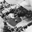
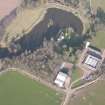
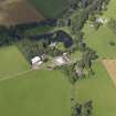
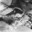
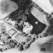
Ecclesmagirdle Chapel


Burial Ground (Medieval), Chapel (15th Century), Church (Post Medieval), Covenanters Grave (17th Century)
Site Name Ecclesmagirdle Chapel
Classification Burial Ground (Medieval), Chapel (15th Century), Church (Post Medieval), Covenanters Grave (17th Century)
Alternative Name(s) Glenearn Church; Ecclesiamagirdle Chapel; Exmagirdle Chapel; Ecclesmoghridain, Old Parish Church
Canmore ID 28021
Site Number NO11NW 2
NGR NO 10743 16344
Datum OSGB36 - NGR
Permalink http://canmore.org.uk/site/28021


- Council Perth And Kinross
- Parish Dron
- Former Region Tayside
- Former District Perth And Kinross
- Former County Perthshire
NO11NW 2 10743 16344.
For discovery of whorl in Ecclesiamagirdle churchyard, see NO11NW 57.
(NO 1074 1634) Ecclesiamagirdle Chapel (NR)
OS 6" map, (1959)
Ecclesiamagirdle or Exmagirdle Chapel is a small, late 15th or 16th century chapel of which the walls only survive. Its churchyard is still in use.
OSA 1792; D MacGibbon and T Ross 1896-7.
(NO 1074 1634) Chapel (NR) (remains of)
OS 6" map, (1970)
Ecclesmagirdle Chapel: probably late pre-Reformation. Small roofless rectangular rubble-built chapel, 25ft 7ins by 11ft 5ins internally. Square-headed SW doorway, single small, round-headed window SE with 'voussoir' lines. Single round-headed E window, square-headed W window altered. Plain square aumbry.
Churchyard wall dated DSC 1651 STIL REA DEI; small collection of 17th century gravestones of note including that of Thomas Smal, covenanting martyr 1645.
SDD List, May 1967.
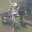
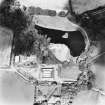
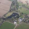
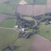
The remains of the former parish church and burial-ground of Ecclesmagirdle stand on a terrace about 40m SW of Ecclesmagirdle House (NO11NW 3.00). Although a roofless shell, the walls have been maintained and survive entire. The church is a simple rectangular structure, measuring 9.62m from ENE to WSW by 5.44m transversely over walls 0.8m in thickness, and it has been built in the gently sloping burial-ground in such a way that its walls drop markedly in level from W to E. The walls are of rubble and mortar construction with ashlar quoins, but it incorporates a number of ashlar blocks evidently reused from an earlier building. There is a round-headed lancet window towards the E end of the S wall, its top formed of a single block with a narrow chamfer around the opening. The face of the block bears a series of shallow incised lines radiating from the chamfer?s edge, thus simulating the voussoirs of an arch. The window itself is a composite feature. The lancet-head is not in situ, and the sill and internally splayed E jamb belong to a rectangular-headed window of two lights, 0.82m in breadth. This has been reduced in size and converted into a lancet by the insertion of the present W jamb, and the replacement of the original lintel by the lancet head. Also in the S wall, towards the W end, there is a rectangular-headed doorway, its opening rebated internally and chamfered externally; the uppermost stone of the E jamb can be seen to be in re-use, as it bears a glazing groove on one side. In the W gable there is a rectangular-headed window, internally splayed, with a broad chamfer on the lintel and jambs. The window has been blocked for the insertion of a round-headed lancet some 0.25m in breadth, its head matching that in the S wall. Another lancet, some 0.37m in breadth but now blocked, can be seen in the E gable. A course of stonework extending the line of the E gable beyond the N wall may be the base of a former buttress.
The internal features of the building comprise scarcements on each gable, and a rectangular aumbry in the E end of the N wall. The Aumbry measures 0.45m in height by 0.39m in width and 0.46m in depth, and is rebated for a door. The scarcement on the E gable is at a height of 1.1m above the ground, below the level of the window splay, while that on the W gable is at 2.1m.
The kirkyard is enclosed by a rubble and mortar wall, some sections of which are now in a state of collapse. The gateway piers, towards the S end of the E side, incorporate a number of reused blocks of chamfered masonry. The uppermost block of the S pier, which bears the incised date 1651, is also finished with a rounded moulding along the reverse edge. The uppermost block of the N pier bears the incised letters S D C. The kirkyard contains several monuments of 17th- to 19th-century date. A number of gravemarkers are simple blocks, possibly reused masonry, either illegible, unmarked, or simply bearing initials. In the SE corner of the yard is the thruch (recumbent gravestone) stone of Thomas Small, who, according to the inscription, died for Country and Covenant on 1 September 1645. On the S side of the church stands a table-tomb, dated 1670 and 1674, which bears crossed mill-rinds, an adze, a set-square, a compass and symbols of mortality.
Visited by RCAHMS (JRS, IF), 27 November 1996.
Standing Building Recording (6 August 2007 - 26 August 2007)
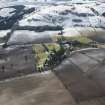
NO 1074 1634 Exmagirdle church is a ruined single-celled building occupying a small, curvilinear churchyard in the Glenearn Estate, where it forms part of the policies. The name Exmagirdle derives from ecclesia and St Grillán, an obscure companion of St Columba, which suggests an early foundation. Fieldwork at the site undertaken from 6–26 August 2007 included a full measured survey of the church, a topographic survey of the churchyard and its immediate vicinity, and geophysical survey of the open areas closest to the church including the grounds of the laird’s house.
The single-celled (9.5 x 5.5m) church retains some medieval architectural features including the E window and an ambry of 15th-century date or earlier, but the whole church has been substantially rebuilt. The lowest course of masonry at the E end projects beyond the existing walls and reveals that the previous medieval church stood 0.5m wider. Its original length is unknown. The churchyard contains a collection of 40 burial monuments ranging from a Covananter’s tombstone dated 1645 to the mid-19th-century lairds with one more recent burial.
www.gla.ac.uk/departments/archaeology/research/projects/serf
Archive currently deposited with the Department of Archaeology, University of Glasgow.
Funder: British Academy, Historic Scotland, Department of Archaeology University of Glasgow, Society of Antiquaries of Scotland.
Geophysical Survey (6 August 2007 - 26 August 2007)
The geophysical survey to the N of the church was unproductive, but in the grounds of the laird’s house it was possible to trace the line of the barmkin of which only the entrance gate survives. Otherwise the survey revealed that the N and W sides of the churchyard had been truncated by modern agricultural use.
www.gla.ac.uk/departments/archaeology/research/projects/serf
Archive currently deposited with the Department of Archaeology, University of Glasgow.
Funder: British Academy, Historic Scotland, Department of Archaeology University of Glasgow, Society of Antiquaries of Scotland.

