
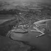
Stonehaven Harbour, Leading Lights


Beacon (19th Century)
Site Name Stonehaven Harbour, Leading Lights
Classification Beacon (19th Century)
Alternative Name(s) 'Stonehaven 2'; 'stonehaven 3'; Shorehead
Canmore ID 280120
Site Number NO88NE 56.10
NGR NO 87699 85430
NGR Description NO 87699 85430 and NO 87689 85432
Datum OSGB36 - NGR
Permalink http://canmore.org.uk/site/280120

- Council Aberdeenshire
- Parish Dunnottar
- Former Region Grampian
- Former District Kincardine And Deeside
- Former County Kincardineshire
NO88NE 56.10 87699 85430 and 87689 85432
Leading Lights [NAT]
OS 1:2500 map, 1977.
(Stonehaven 2 (forming pair of leading lights with Stonehaven 3): location cited as NO 877 854). On edge of inner wall of harbour: prob. late 19th century. Tall square-section wooden post with chamfered edges, from top of which is bracketed box-shaped metal lantern with pyramidal roof.
(Stonehaven 3 (forming pair of leading lights with Stonehaven 2): location cited as NO 877 854). Prob. late 19th century. Box-shaped lantern bracketed from wall of former warehouse, with fixed ladder access. Bottom of ladder protected by wooden fence.
J R Hume 1997.
Field Visit (April 2023)
NO 87699 85430 Visited during fieldwork by SCAPE. Beacon is as described, but there is no ladder. It is in good condition.
Information from S Boyd and J Hambly - Scottish Coastal Archaeology and the Problem of Erosion (SCAPE)

