
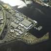
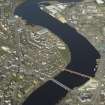
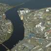
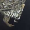
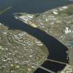
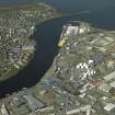
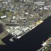
Inverness Harbour, Navigation Light


Beacon (Period Unassigned)
Site Name Inverness Harbour, Navigation Light
Classification Beacon (Period Unassigned)
Alternative Name(s) River Ness; Inverness Harbour, Beacon
Canmore ID 280012
Site Number NH64NE 129.13
NGR NH 6603 4693
Datum OSGB36 - NGR
Permalink http://canmore.org.uk/site/280012


- Council Highland
- Parish Inverness And Bona
- Former Region Highland
- Former District Inverness
- Former County Inverness-shire
NH64NE 129.13 6603 4693
Navigation Light [NAT]
OS 1:10,000 map, 1992.
This beacon is sited to guard the E side of the river entrance into Inverness Harbour (NH64NE 129.00). It is not indicated on the OS AIB landline (GIS, 2006).
Information from RCAHMS (RJCM), 30 March 2006.

