
Pricing Change
New pricing for orders of material from this site will come into place shortly. Charges for supply of digital images, digitisation on demand, prints and licensing will be altered.
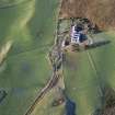
Colmeallie


Township (Period Unassigned)
Site Name Colmeallie
Classification Township (Period Unassigned)
Canmore ID 279711
Site Number NO57NE 25
NGR NO 5644 7825
Datum OSGB36 - NGR
Permalink http://canmore.org.uk/site/279711

- Council Angus
- Parish Edzell
- Former Region Tayside
- Former District Angus
- Former County Angus
NO57NE 25 5644 7825
This township is situated on the hillside to the NW of the 19th century farmsteading and comprises the footings of at least four buildings, a kiln and several enclosures interspersed with ruinous field banks, forming large enclosures.
Information from RCAHMS (DCC) 11 0ctober 2005

