
Quendale, The Shurg


Military Camp (20th Century)
Site Name Quendale, The Shurg
Classification Military Camp (20th Century)
Alternative Name(s) Quendale Farm
Canmore ID 279556
Site Number HU31SE 106
NGR HU 3728 1331
NGR Description Centred HU 3728 1331
Datum OSGB36 - NGR
Permalink http://canmore.org.uk/site/279556


- Council Shetland Islands
- Parish Dunrossness
- Former Region Shetland Islands Area
- Former District Shetland
- Former County Shetland
HU31SE 106 centred 3728 1331
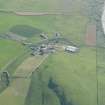
A military camp has been identified from vertical air photographs (540/A/ 466, 4003-4005, flown 25 March 1950), in a field immediately NE of Quendale Farm (HU31SE 101).
The photographs show that the camp consisted of at least 31 huts, though by the date of the image most had been reduced to concrete hut bases.
It is not know for what military installation the camp supplied accommodation.
Information from RCAHMS (DE), March 2006

