
Pricing Change
New pricing for orders of material from this site will come into place shortly. Charges for supply of digital images, digitisation on demand, prints and licensing will be altered.
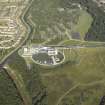
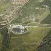
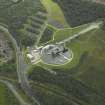
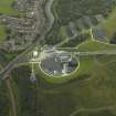
Falkirk, Lime Road, Millennium Wheel, Lower Lock, Footbridge


Footbridge (Period Unassigned)
Site Name Falkirk, Lime Road, Millennium Wheel, Lower Lock, Footbridge
Classification Footbridge (Period Unassigned)
Alternative Name(s) The Falkirk Wheel; Millennium Link; Forth And Clyde Canal; Port Downie
Canmore ID 279418
Site Number NS88SE 198.06
NGR NS 85235 80240
Datum OSGB36 - NGR
Permalink http://canmore.org.uk/site/279418


- Council Falkirk
- Parish Falkirk
- Former Region Central
- Former District Falkirk
- Former County Stirlingshire

