
Castle Law, Abernethy


Fort (Prehistoric)
Site Name Castle Law, Abernethy
Classification Fort (Prehistoric)
Alternative Name(s) Castlelaw; Abernethy
Canmore ID 27917
Site Number NO11NE 12
NGR NO 1830 1533
Datum OSGB36 - NGR
Permalink http://canmore.org.uk/site/27917


- Council Perth And Kinross
- Parish Abernethy (Perth And Kinross)
- Former Region Tayside
- Former District Perth And Kinross
- Former County Perthshire
NO11NE 12 1830 1533.
(NO 183 153) Fort (NR)
OD 6" map, (1959)
Not to be confused with Castle Law, Forgandenny (NO01NE 5).
For polished stone axe found in excavations (c. 1898), see NO11NE 21. For barbed-and-tanged chert arrowhead found at NO 177 154, see NO11NE 119.
The type site of the'Abernethy complex' of camps with timber-laced ramparts : dated by Mrs Cotton somewhere between c.60 BC and the Agricolan conquest of Scotland.
An inner and an outer wall were discovered by excavation: the inner wall, 18-25ft thick, being pierced by a double row of traverse rectangular beam holes and two longitudinal channels. Beam holes were also found in the outer wall. There was no sign of an entrance.
Nothing structural was found in the interior except a rock cistern.
M A Cotton 1954; D Christison and J Anderson 1899.
Castle Law, Abernethy, looks out over the confluence of the Rivers Earn and Tay from a distance of 2 miles SW of the Roman fort at Carpow (NO21NW 24.00). It was excavated between 1896 and 1898, when it was found to consist of a main enclosure, measuring 136 ft (41.5m) by 51 ft (15.5m), which was covered on the W by an outer wall up to 18 ft (5.5m) thick. The inner wall, varying in thickness from 18 ft (5.5m) to 21 ft (6.4m) and still standing to a height of 7 ft (2.1m), was found to contain sockets for horizontal timbers running both from front to back and longitudinally within the wall. A rock-cut well was found in the interior.
This fort was the nucleus of Childe's 'Abernethy Complex'. The discovery in this and other forts with timber-laced walls of such objects as La Tene Ic brooches led him to suppose that such forts must be assignable to a date well back in the second half of the first millennnium BC if, for the sake of argument, the owners of the brooches and the builders of the forts were one and if, as one of the principal techniques of archaeology would have it, the brooches could be used for dating purposes.
R W Feachem 1963.
Centred NO 1830 1533. The fort, generally as previously described, is almost completely destroyed, but is best preserved at its west end where the inner and outer faces of two defensive walls can be seen.
Surveyed at 1/2500.
Visited by OS (W D J) 30 July 1965.
This fort was partly excavated in 1896-8, and the report contains a fine photograph of the sockets left by the timber lacing. Much of the walling can still be seen, though this particularly interesting feature has collapsed. The timber-laced wall, from 5.5m to 7.5m thick and probably 3 or 4m high originally, encloses a rather irregular oval of about 0.05 ha; there is no entrance and the only feature in the interior is a small well. On the W, there is a thinner outer wall, which is not timber-laced. The position is rather similar to that of Castle Law, Forgandenny (NO01NE 5), not far away, and here also a stream has been crossed by two dams, one of which still holds water. The outer wall may have protected the approach to the water, but its N end is ruinous.
A H A Hogg 1975.
Bronze spiral finger-ring.
E W MacKie 1971.
Fragment of lid of carved bowl, held in NMS.
C Earwood 1993.
The remains of this fort are largely as previously described; it is grass grown and the remains of some of the excavation trenches are visible, in particular the one that was dug along the line of the inner wall face of the inner rampart.
Visited by RCAHMS (JRS, IF), 27 November 1996.
The following items from the fort on Castle Law, Abernethy were presented to the (former) National Museum of Antiquities of Scotland by the Excavation Committee [of the Society of Antiquaries of Scotland] in 1899 and are held in the Royal Museum of Scotland under the accession numbers cited:
GP 17-18 stone lamps
GP 20 hammerstone
GP 21 grooved piece of sandstone
GP 22 polisher of jet
GP 23-4 clay peelets
GP 25-6 chips of flint
GP 27-34 jet ring and fragment, bronze finger-ring, bronze fibula, rubbed bone fragements
GP 35-40 iron objects
GP 41-2 portions of two wooden vessels
GP 43 bone tool handle
GP 44-6 jaw bones of ox
GP 47 horn cores of goat
GP 48 tine of roe-deer
GP 49 leg-bone of ox
GP 50-4 bones, artifically split
GP 55 four small fragments of coarse pottery.
Information from National Museums of Scotland typescript continuation catalogue per Mr T Cowie (NMS), 6 February 1998.
Photographic Record (14 March 1898)
Photographs of the excavation at the fort at Castle Law, Abernethy by P M Macintyre 1898.
Field Visit (14 June 2013)
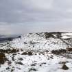
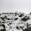
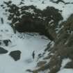
This fort stands on a spur on the E flank of Castle Law overlooking the village of Abernethy 1km to the NE, with steep slopes on all sides bar the W, from which direction the site is most easily approached. The fort comprises a roughly oval area, measuring about 42m from NE to SW by 18m transversely, within a ruinous timber-laced stone wall. At the SW end it appears to survive almost as intact as when it was first revealed by excavation in the late 1890s (Christison and Anderson 1899). Here, the wall is up to 6m thick and stands to an external height of 2.4m, and although there has been subsequent erosion to the exposed outer wall-face (in which the empty sockets of horizontal timbers were visible), the bulk of the wall appears to survive relatively intact. Elsewhere, however, this wall has been heavily robbed, reducing its appearance to little more than a low spread of rubble punctuated by quarry-scoops. A second wall, also found on excavation to be timber-laced and which stands outside the first at the W end, seems also to have survived well since the excavation which exposed its inner face. It measures 4.5m in thickness at its SE end (where the relationship with the inner wall is not clear) but is of indeterminate thickness at its NW end, where it is situated on the crest of a steep slope. Most of the debris filling the gap between the two walls was removed in the 1890s, but a small tump of unexcavated material standing 2m high remains. The spoil from this part of the excavation was deposited immediately to the N, resulting in a large heap of stone debris that runs down the slope as far as the waterlogged ground at the bottom. The possible door jambs noted by Christison and Anderson were not seen on the date of visit.
The only features of note within the interior of the fort, other than the cistern or the well mentioned in previous accounts, are several excavation trenches which are undated but may represent work undertaken by two local men – Alexander Mackie and James Marr between 1895 and 1897. At the centre of the fort, on the highest part of the spur, there is a low cairn-like feature measuring 4m from N to S by 3m transversely and no more than 0.3m in height. Given its location, it may be a stance for a 19th century survey station.
To the NW of and situated on a terrace below the fort are two areas which were respectively labelled ‘Loch’ and ‘Marsh’ by Christison and Anderson (Ibid, Fig.2). The ‘Loch’, which is actually little more than a shallow pond, is a man-made feature formed by damming a shallow gully that naturally drains to the NE. It measures about 47m from NE to SW by 26m transversely behind an earthen bank 33m in length by up to 11m in thickness and 1.2m in external height and probably no more than 1m internally. A narrow break through the top of this bank 12m from the NW end represents either the remains of a contemporary sluice or a later drain. The exact purpose and date of this pond is not known. It cannot be a mill pond because there is no recorded mill nearby and the outflow could only have descended the impractically steep N slope of the hill. It may be a curling pond, but the location is comparatively remote and would have proved difficult to access in winter conditions. The fabric of the dam might have been expected to include stone from the ruined fort, which it does not, but the builders may always have intended to construct the dam with material gained from the creation of the pond. If this was the case, then it should be no surprise to find that the dam appears to comprise a largely earthen bank, something that may explain the extraordinary thickness in relation to its height.
The ‘Marsh’ is a comparatively small, roughly triangular, area of steeply sloping ground defined on the S by the natural slope below the fort, on the W by the dam and on the NE by a bank measuring about 45m in length by up to 8m in thickness and now no more than 0.8m in height. The NW end of this bank, which appears to have little stone content, terminates on a low outcrop ridge immediately NE of the NW end of the dam. The SE end is lost beneath the scree slope below the fort. The term ‘Marsh’ is a misnomer and probably arose from the fact that water running out of the ‘Loch’ has tended to pool in the bottom (NW) end of the area. A break in the bank close to the NW end probably represents an attempt to drain the resulting waterlogged ground. The exact purpose and date of this bank, nor its relationship either to the fort or the pond, is not known. Further, it is difficult to imagine the context of the bank in relation to the fort. Whilst its SE end, now masked below scree, may have originally climbed to slope to link with the E end of the fort, the NW end of the bank simply terminates on a low outcrop ridge.
Visited by RCAHMS (JRS, IP GG), 14 June 2013.
Measured Survey (June 2013)
RCAHMS and members of the local community surveyed the fort at Castle Law, Abernethy in June 2013 during Perthshire Archaeology Month. The site was surveyed with plane-table and self-reducing alidade at a scale of 1:500 and resultant plan was redrawn in vector graphics software at a scale of 1:1000.
Note (6 May 2015 - 31 May 2016)
This small fortification is situated on a rocky knoll that forms the tip of the NE spur of Castle Law, from which the ground falls away steeply into the valley of the Ballo Burn on the E and to the floodplain of the River Tay on the N. But for the excavations carried out by two local men about 1895-7, completed by the Society of Antiquaries in 1898, it is unlikely that the fort would have assumed any significance in the study Scottish hillforts. Nevertheless, the excavations uncovered what appears to have been a thick timber-laced wall enclosing an oval area measuring 43m from NE to SW by 15.5m transversely (0.06ha); tiers of openings were exposed in the outer face of the wall, which on the SW measures about 6m in thickness and still stands 2.4m high externally. On dismantling parts of the wall they found unfilled channels left by the decayed timbers ran back up to 3m into the core of the wall, where several longitudinal channels were also located. An outer wall at least 4.5m thick, and also timber-laced, cuts eccentrically across the spine of the knoll on the SW and is assumed to be an outwork to the inner wall on this the most accessible side. Large dumps of spoil from the excavations lie to the NW and SW and the interior is scarred with excavation trenches, which revealed a rock-cut cistern on the SE. No trace of an entrance was located. The only other features of note are a dam of unknown date creating a pond in the hollow below the fort on the W, and a second bank crossing the hollow on the lip of the slope to its NE; springing from the foot of the scree of debris below the NW flank fort on the SE, and resting on the end of a spine of outcrop on the NW, the purpose of the latter is unknown.
Information from An Atlas of Hillforts of Great Britain and Ireland – 31 May 2016. Atlas of Hillforts SC3030
Excavation (28 June 2017 - 8 July 2017)
NO 1829 1533 In 2017 AOC supported Tay LP, Perth and Kinross Heritage Trust and local volunteers in an evaluation at the hillfort of Moredun Top.
The work, undertaken 28 June – 8 July 2017, aimed to increase understanding of the date and chronology of the hillfort structures, notably two ramparts. It also hoped to assess any impact or damage to the monument after an earlier antiquarian excavation, which left wall faces exposed for over a hundred years, and to establish a monument care plan.
The inner and outer ramparts were a monumental, stone built structure, with both walls showing some evidence for timber slots, utilised in the timber lacing. The timber slots were best exposed in the outer face of the outer rampart, which had been protected by collapse and soil deposits. The internal area of the hillfort underlay a mound of upcast and spoil from the original excavations to expose the inner face of the inner rampart. Removal of this material exposed a charcoal rich original ground surface, with a curvilinear arrangement of stone, which has been interpreted as a paving feature. A quern stone was reused within this structure, and sherds of prehistoric ceramic pottery were recovered from, and above, this context. In addition, a small fragment of a crucible was discovered from this internal area, with residues indicative of copper alloy working, possibly bronze.
Evidence for manipulation of bedrock can be seen in the area between the ramparts, perhaps to create a steeper gradient or for use. A large pounder was found in this area, which may be indicative of the technology used for such activity.
Archive: NRHE (intended)
Funder: Tay Landscape Partnership
David Strachan, Martin Cook, Sophie Nicol and Katie Roper – Perth and Kinross Heritage Trust, Tay Landscape Partnership and AOC Archaeology Group
(Source: DES, Volume 18)
Excavation (22 June 2017 - 12 July 2017)
NO 1829 1533 A community excavation was undertaken, 22 June – 12 July 2017, at the hillfort as part of the Tay Landscape Partnership, led by Perth and Kinross Heritage Trust with local volunteers, and supported by AOC. The work aimed to increase understanding of the date and chronology of the hillfort structures, notably two ramparts. It was also hoped to assess any impact or damage to the monument after an earlier antiquarian excavation, which left wall faces exposed for over a hundred years, and to establish a monument care plan.
The inner and outer ramparts were monumental, stone built structures, with both walls showing some evidence for timber slots, utilised in the timber lacing. The timber slots were best exposed in the outer face of the outer rampart, which was protected by collapse and soil deposits.
The internal area of the hillfort underlay a mound of upcast and spoil from the original excavations to expose the inner face of the inner rampart. Removal of this material exposed a charcoal-rich original ground surface, with a curvilinear arrangement of stone, which has been interpreted as a paving feature. A quern stone was reused within this structure, and sherds of prehistoric pottery were recovered from, and above, this context. In addition, a small fragment of a crucible was discovered from this internal area, with residues indicative of copper alloy working, possibly bronze.
Evidence for manipulation of bedrock can be seen in the area between the ramparts, perhaps to create a steeper gradient or for use. A large pounder was found in this area, which may be indicative of the technology used for such activity.z
Archive: NRHE (intended)
Funder: Tay Landscape Project
Jamie Humble and Martin Cook – AOC Archaeology Group
(Source: DES, Volume 19)
Information from OASIS Id: aocarcha1-333444 (J. Humble) March 2018
Field Visit (26 February 2021)
NO 18368 15264 The proposed site of a new general purpose shed and route of associated access track were surveyed by Alder Archaeology on 26th February, 2021 prior to construction. The work took place on 26th February 2021. The route ran along the E slope of Aytoun Hill, on the summit of which is located the fort of Castle Law (SM2477). The shed location was on the lip of a large, disused stone quarry below the hillfort, which effectively screened the development from the monument. Outlying quarry buildings were noted. No other archaeological remains were encountered.
Archive: NRHE (intended) Funder: K G Contracts Ltd
C Fyles – Alder Archaeology Ltd
(Source: DES Vol 22)
OASIS ID: alderarc1-416769

