
Bernera Bridge


Road Bridge (20th Century)
Site Name Bernera Bridge
Classification Road Bridge (20th Century)
Alternative Name(s) Great Bernera; Bearnaraigh; Isle Of Lewis; Loch Roag; Loch Barraglom
Canmore ID 279088
Site Number NB13SE 60
NGR NB 16478 34177
Datum OSGB36 - NGR
Permalink http://canmore.org.uk/site/279088


- Council Western Isles
- Parish Uig
- Former Region Western Isles Islands Area
- Former District Western Isles
- Former County Ross And Cromarty
NB13SE 60 16478 34177
Bernera Bridge [NAT]
OS 1:10,000 map, 1974.
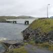
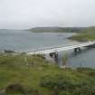
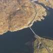
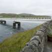
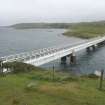
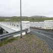
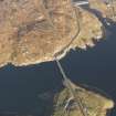
This bridge carries the B8059 public road over a narrow channel between the island of Great Bernera (Bearnaraigh) to the N and the Isle of Lewis (to the S). Loch Roag and Loch Barraglom lie to the W and E respectively.
The location assigned to this record defines the centre of the structure. The available map evidence indicates that it extends from NB c. 16469 34247 to NB c. 16491 34112.
Information from RCAHMS (RJCM), 22 February 2006.
Construction (1953)
May be the first pre-stressed concrete bridge in Britain.
R Paxton and J Shipway, 2007
Publication Account (2007)
Bernera Bridge
(Institute Civil Engineers Historic Engineering Works no. HEW 1812)
This structure, linking Bernera with Lewis in 1953, is believed to be the first pre-stressed concrete bridge built in Britain. It has three spans of 108 ft, each of which is formed of three parallel beams of pre-cast concrete segments stressed together and capped by an in situ concrete deck slab. The width is 13 ft between parapets. Because of the limited carrying capacity of the roads and other bridges in the area, it was agreed that the bridge should be designed for two-thirds of the full Ministry of Transport loading.
Each span consists of three pre-cast ‘U’ girders posttensioned on shore each with two straight and two curved cables of 32 wires by the Magnel–Blaton system. The beams were cast on shore in eight ‘U’ segments 11 ft 8 in. long, 4 ft 8 in. deep and 3 ft wide and two solid end blocks 5 ft 6 in. long. The completed beams each weighed 52 tons and their erection over water was facilitated by a temporary steel-lattice girder. The abutments and piers are of conventional design and consist of cylindrical shafts 7 ft 3 in. diameter placed 14 ft apart. The piers are founded on a concrete base slab founded on stiff boulder clay, and are capped by reinforced-concrete beams on which the pre-stressed beams are carried.
The engineers were Blyth & Blyth, Edinburgh, in collaboration with the County Engineer J. A. Shaw. The main contractor was A. A. Stuart & Sons (Glasgow) Ltd and the subcontractor for the pre-stressing was Stressed Concrete Design Ltd. The cost was £70 111.
While underwater work was in progress, divers reported traces of what appeared to have been a stone-built causeway about 6 ft west of the centreline of the bridge and parallel to it. It was about 7 ft wide and built of hand placed boulders ‘some of which were of considerable size’. There is no record of a causeway here, but it may be significant that two standing stones in Bernera overlook the site.
R Paxton and J Shipway, 2007.
Reproduced from 'Civil Engineering heritage: Scotland - Highlands and Islands' with kind permission from Thomas Telford Publishers.

