
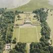
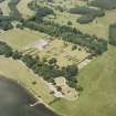
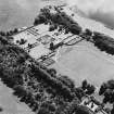
Kinross, Bruce Mortuary Chapel


Burial Ground (Post Medieval), Church (17th Century)
Site Name Kinross, Bruce Mortuary Chapel
Classification Burial Ground (Post Medieval), Church (17th Century)
Alternative Name(s) Old Parish Kirk; East Burial Ground
Canmore ID 27880
Site Number NO10SW 10
NGR NO 12840 01815
Datum OSGB36 - NGR
Permalink http://canmore.org.uk/site/27880


- Council Perth And Kinross
- Parish Kinross
- Former Region Tayside
- Former District Perth And Kinross
- Former County Kinross-shire
NO10SW 10 12840 01815.
(NO 1283 0182) Church (NR) (Remains of)
OS 6" map (1938)
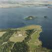
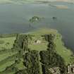
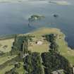
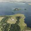
Before 1742 the parish church of Kinross stood within the old burial ground immediately beside Loch Leven.
G Buchanan 1938
The church is mentioned in a charter of AD 1314.
Reg Magni Sig Reg Scot 1306-1424
No trace of this church now remains. Its site is probably that now occupied by the mortuary chapel at NO 1284 0181. This chapel bears the date '1675', but this appears to be a modern insertion.
Visited by OS (WDJ) 19 December 1963
EXTERNAL REFERENCE
Mitchell Library - Annan Vol (2-58) - 1 photograph no32

