
Pricing Change
New pricing for orders of material from this site will come into place shortly. Charges for supply of digital images, digitisation on demand, prints and licensing will be altered.
Dunglass, Present Road Bridge


Road Bridge (20th Century)
Site Name Dunglass, Present Road Bridge
Classification Road Bridge (20th Century)
Alternative Name(s) Dunglass Burn; Dunglass Dean
Canmore ID 278524
Site Number NT77SE 114
NGR NT 77119 72220
Datum OSGB36 - NGR
Permalink http://canmore.org.uk/site/278524


- Council Scottish Borders, The
- Parish Cockburnspath
- Former Region Borders
- Former District Berwickshire
- Former County Berwickshire
NT77SE 114 76992 72085
See also NT77SE 37, NT77SE 43, NT77SE 44, NT77SE 45.
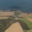
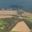
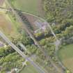
This bridge is of recent construction, and is not depicted on the 1987 edition of the OS 1:10,000 map. It carries the current line of the A1 public road over the Dunglass Burn, which flows in Dunglass Dean and here forms the boundary between the parishes of Oldhamstocks (East Lothian) and Cockburnspath (Berwickshire).
The bridge is situated in the middle of (and above) a group of predecessor structures, for which see NT77SE 37, NT77SE 43, NT77SE 45. It is immediately to the E of its predecessor (NT77SE 43).
The location assigned to this record defines the centre of the structure. The available map evidence suggests that it extends from NT c. 77080 72236 to NT c. 77151 72203.
Information from RCAHMS (RJCM), 25 March 1998.

