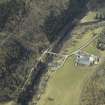
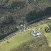
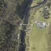
Accessibility

Font Size

100% 150% 200%

Background Colour

Default Contrast
Close Reset

Fairnilee, Steading

Farmstead (Period Unassigned)

Site Name Fairnilee, Steading

Classification Farmstead (Period Unassigned)

Canmore ID 278296

Site Number NT43SE 158.01

NGR NT 45828 32699

Datum OSGB36 - NGR

Permalink http://canmore.org.uk/site/278296

Ordnance Survey licence number AC0000807262. All rights reserved.
Canmore Disclaimer. © Bluesky International Limited 2025. Public Sector Viewing Terms

Toggle Aerial | View on large map

Digital Images

Oblique aerial view centred on the road bridge with the farmhouse, farmsteading and sawmill adjacent, taken from the ENE.
Oblique aerial view centred on the road bridge with the farmhouse, farmsteading and sawmill adjacent, taken from the ENE.Oblique aerial view centred on the road bridge with the farmhouse, farmsteading and sawmill adjacent, taken from the NNE.Oblique aerial view centred on the road bridge with the farmhouse, farmsteading and sawmill adjacent, taken from the E.

Collections

Administrative Areas

  • Council Scottish Borders, The
  • Parish Caddonfoot
  • Former Region Borders
  • Former District Ettrick And Lauderdale
  • Former County Selkirkshire

Archaeology Notes

Activities

Sbc Note

Visibility: Evidence for this site, or the origins of this site, comes from documentary sources. Nothing may be visible at this location.

Information from SBC.

References

MyCanmore Image Contributions


Contribute an Image

MyCanmore Text Contributions