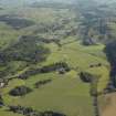
Accessibility

Font Size

100% 150% 200%

Background Colour

Default Contrast
Close Reset

Nether Largie

Farmstead (Period Unassigned)

Site Name Nether Largie

Classification Farmstead (Period Unassigned)

Alternative Name(s) Nether Largie Steading

Canmore ID 278165

Site Number NR89NW 163

NGR NR 82852 98063

Datum OSGB36 - NGR

Permalink http://canmore.org.uk/site/278165

Ordnance Survey licence number AC0000807262. All rights reserved.
Canmore Disclaimer. © Bluesky International Limited 2025. Public Sector Viewing Terms

Toggle Aerial | View on large map

Digital Images

Oblique aerial view centred on the remains of the chambered cairn with the remains of the standing stone and stone circles and the farmstead adjacent, taken from the ESE.
Oblique aerial view centred on the remains of the chambered cairn with the remains of the standing stone and stone circles and the farmstead adjacent, taken from the ESE.General oblique aerial view of the Kilmartin valley centred on the remains of the chambered cairn, standing stones, stone setting and cairns and the farmstead and school, taken from the S.General oblique aerial view of the Kilmartin valley centred on the remains of the chambered cairn, standing stones, stone setting and cairns and the farmstead and school, taken from the S.Oblique aerial view centred on the remains of the chambered cairn with the remains of the standing stone and the school and farmstead adjacent, taken from the S.General oblique view of the valley showing the remains of the standing stones and cairns at Kilmartin, and the school and farmstead, taken from the SE.General oblique aerial view of the Kilmartin valley centred on the remains of the chambered cairn, standing stones, stone setting and cairns and the farmstead and school, taken from the SSW.Oblique aerial view centred on the remains of the chambered cairn with the remains of the standing stone and stone circles and the farmstead adjacent, taken from the SE.General oblique aerial view of the Kilmartin valley centred on the remains of the chambered cairn, standing stones, stone setting and cairns and the farmstead and school, taken from the S.Oblique aerial view centred on the farmstead and school, with the remains of the cairns adjacent, taken from the WSW.Oblique aerial view centred on the farmstead and school, with the remains of the cairns adjacent, taken from the SSW.General oblique view of the valley showing the remains of the standing stones and cairns, and the school and farmstead, taken from the SW.General oblique view of the valley showing the remains of the standing stones and cairns, and the school and farmstead, taken from the SSW.Oblique aerial view centred on the farmstead and school, with the remains of the cairn adjacent, taken from the NW.Oblique aerial view centred on the farmstead and school, with the remains of the cairn adjacent, taken from the NE.

Administrative Areas

  • Council Argyll And Bute
  • Parish Kilmartin
  • Former Region Strathclyde
  • Former District Argyll And Bute
  • Former County Argyll

Archaeology Notes

NR89NW 163 82852 98063.

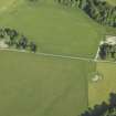
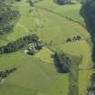
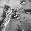
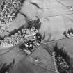
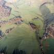
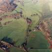
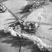
This courtyard farmstead has a house in the centre of the S side and sheep shelters to the rear.

Information from RCAHMS (SS) 12 January 2006.

References

MyCanmore Image Contributions


Contribute an Image

MyCanmore Text Contributions