
Craigdhu


Farmstead (Period Unassigned)
Site Name Craigdhu
Classification Farmstead (Period Unassigned)
Alternative Name(s) Craigdhu Farm
Canmore ID 278106
Site Number NM80NW 75
NGR NM 82074 05454
Datum OSGB36 - NGR
Permalink http://canmore.org.uk/site/278106


- Council Argyll And Bute
- Parish Craignish
- Former Region Strathclyde
- Former District Argyll And Bute
- Former County Argyll
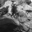
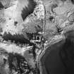
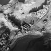
NM80NW 75 82074 05454.
This courtyard farmstead dates from c.1880 and has an integral farmhouse on one side of the central entrance. There is a stable with some stalls in situ and a loft over, and a barn, a dairy, a byre and cart sheds that open outwards. Some Dutch barns are situated adjacent to the farmstead. The farmstead buildings are one to one-and-a-half storeys tall and are built of rubble with slate roofs.
Information from RCAHMS (SS) 2006 12 January 2006.

