
Pricing Change
New pricing for orders of material from this site will come into place shortly. Charges for supply of digital images, digitisation on demand, prints and licensing will be altered.
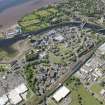
Dumbarton, Dalreoch Railway Bridge


Railway Bridge (19th Century)
Site Name Dumbarton, Dalreoch Railway Bridge
Classification Railway Bridge (19th Century)
Alternative Name(s) River Leven; Dalreoch Railway Viaduct
Canmore ID 277926
Site Number NS37NE 198
NGR NS 39297 75640
Datum OSGB36 - NGR
Permalink http://canmore.org.uk/site/277926


- Council West Dunbartonshire
- Parish Dumbarton
- Former Region Strathclyde
- Former District Dumbarton
- Former County Dunbartonshire
NS37NE 198 39297 75640
Dalreoch Railway Viaduct. Steel girder bridge, c. 1870, crossing the [River] Leven E of Dalreoch Station [NS37NE 83] in five spans. Tapering ashlar piers, with rounded cutwaters to high-tide level. Vaulted occupation arches in W and E abutments.
The five laminated timber arches of the original bridge (built 1847-8) were replaced with steel beams, shortly after the North British Rly took over the line.
J Gifford and F A Walker 2002.
This bridge remains in regular use by passenger traffic, carrying the electrified suburban railway line to Helensburgh and Balloch over the River Leven between Dumbarton Central Station (NS37NE 48) and Dalreoch Station (NS37NE 86), to the E and W respectively. It also carries non-electrified traffic to Oban, Fort William and Mallaig.
The location assigned to this record defines the centre of the span. The available map evidence suggests that the bridge extends from NS c. 39254 75672 to NS c. 39348 75626.
The river here forms the boundary between the parishes of Cardross (to the W) and Dumbarton (to the E).
Information from RCAHMS (RJCM), 29 December 2005.

