
Pricing Change
New pricing for orders of material from this site will come into place shortly. Charges for supply of digital images, digitisation on demand, prints and licensing will be altered.
Dalmunzie


Building(S) (Medieval) - (Post Medieval), Retting Pond(S) (Post Medieval)
Site Name Dalmunzie
Classification Building(S) (Medieval) - (Post Medieval), Retting Pond(S) (Post Medieval)
Canmore ID 27732
Site Number NO07SE 5
NGR NO 0950 7059
Datum OSGB36 - NGR
Permalink http://canmore.org.uk/site/27732


- Council Perth And Kinross
- Parish Kirkmichael (Perth And Kinross)
- Former Region Tayside
- Former District Perth And Kinross
- Former County Perthshire
Field Visit (27 July 1987)
NO07SE 5 0950 7059.
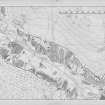
The remains of three buildings (two within an enclosure), a series of artificial terraces and a length of revetted stream bank are visible some 730m SE of Dalmunzie Hotel. The site lies to either side of a low tributary of the Shee Water and is situated within permanent pasture.
On the opposite side of the stream there are a number of artificial terraces which have been fed by water channels from upslope; they are almost certainly flax-retting ponds. This is probably the site of the mill indicated by Stobie (1783).
1. NO 0944 7058 The remains of this building measure 7m ESE-WNW by 5.3m over rubble wall-footings up to 1.4m in thickness and 0.5m in height. There is an entrance midway along the S side and at the E end there is an outshot (4.7m ESE-WNW by 4m overall). The outshot has a deep batter on its E wall and an entrance in its SE corner.
2. NO 0952 7064 To the N there are the remains of a building measuring about 14.8m WNW-ESE by 4.8m over turf-covered wall-footings up to 1.1m in thickness and 0.3m in height. Immediately SW there is a second building (10.2m WSW-ENE by 5.1m over wall-footings 1m thick and 0.3m high). Both lie within an enclosure at the foot of the slope on the W side of the stream.
Visited by RCAHMS (JRS) 27 July 1987.
RCAHMS 1990

