
Following the launch of trove.scot in February 2025 we are now planning the retiral of some of our webservices. Canmore will be switched off on 24th June 2025. Information about the closure can be found on the HES website: Retiral of HES web services | Historic Environment Scotland
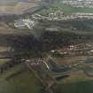
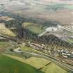
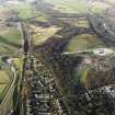
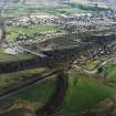
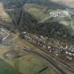
Union Canal, Lock, Landscape Monitoring Point


General View (21st Century), Lock (21st Century)
Site Name Union Canal, Lock, Landscape Monitoring Point
Classification General View (21st Century), Lock (21st Century)
Canmore ID 277285
Site Number NS87NE 173
NGR NS 8536 7960
Datum OSGB36 - NGR
Permalink http://canmore.org.uk/site/277285


- Council Falkirk
- Parish Falkirk
- Former Region Central
- Former District Falkirk
- Former County Stirlingshire
Project (24 July 2018)
Landscape Monitoring
A programme of landscape monitoring in conjunction with Scottish Natural Heritage and Historic Environment Scotland. The monitoring comprises air photography of selected points across Scotland. The aim of the monitoring is to produce a set of case study locations that will be used to complement the monitoring of Land-use change being carried out as part of the Historic Land-use Assessment.
Information from HES (Survey and Recording) (M Middleton) 2018

