
Following the launch of trove.scot in February 2025 we are now planning the retiral of some of our webservices. Canmore will be switched off on 24th June 2025. Information about the closure can be found on the HES website: Retiral of HES web services | Historic Environment Scotland
Castlelaw And Dreghorn Training Area


Firing Range (20th Century), Firing Range (First World War), Military Training Site (20th Century), Military Training Site (First World War)
Site Name Castlelaw And Dreghorn Training Area
Classification Firing Range (20th Century), Firing Range (First World War), Military Training Site (20th Century), Military Training Site (First World War)
Canmore ID 277106
Site Number NT26NW 464
NGR NT 220 664
NGR Description NT 220 664 (centre)
Datum OSGB36 - NGR
Permalink http://canmore.org.uk/site/277106


- Council Edinburgh, City Of
- Parish Edinburgh (Edinburgh, City Of)
- Former Region Lothian
- Former District City Of Edinburgh
- Former County Midlothian
NT26NW 464 220 664 (centre)
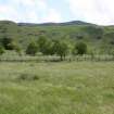
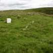
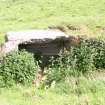
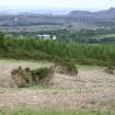
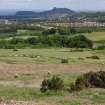
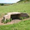
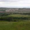
The Castlelaw and Dreghorn Training Area (CDTA) is situated at the NE end of the Pentland Hills, its northern end on the OS 1:10,000 mapsheet and its southern end on (see NT26SW 135). This part comprises a series of hills and deeply-incised burn-gullies separated from the Edinburgh City bypass (A720) by a narrow corridor of relatively flat farmland. The area has been used for military training since about the First World War, and an RAF vertical aerial photograph taken in 1947 (CPE/Scot/UK 277, 5266) shows in detail the form and extent of systems of practice-trenches, rifle ranges and associated structures.
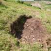
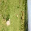
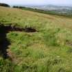
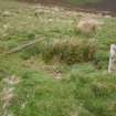
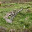
The small-arms ranges (NT26NW 472), which occupied the flat ground S of Dreghorn Mains (NT26NW 359), were decommissioned about 1985, when the target butts, firing-lines and associated buildings were demolished and the area was reinstated as pasture, but short stretches of the practice-trenches (NT26NW 472) are still visible. On higher ground to the S and SW there a grenade range (NT26NW 451), an installation of unknown function (NT26NW 454), a number of platforms and stances (CDTA05 117, 118, 122), and numerous shell- and mortar-craters. Very little is now visible of the two grenage ranges (CDTA05 273-4) and the mortar range (CDTA05 275), which were situated on the gentle E flank of White Hill.
Nothing is now visible of the recreation ground that lay in what is now an arable field 200m W of Dreghorn Mains. The 1947 RAF vertical aerial photograph shows an oval 400 yard running track surrounded by twenty-four tents; an Ordnance Survey vertical aerial photograph taken in 1969 (OS 69 235, 461) suggests that the land had reverted by then to arable or improved pasture.
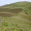
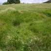
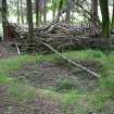
In the rough pasture that occupies the flat ground and the foot of the steep, N-facing slope below White Hill Plantation there are numerous short lengths of shallow trench, which appear to have been dug some time after 1969. Hundreds of locations are visible where the turf has been removed to create shallow fox-holes or bivouacs. These can be found throughout the training area, but they are most common in woodland on the lower ground, some being dug as recently as within the past year.
(CDTA05 117, 118, 122, 273-5)
Visited by RCAHMS (AGCH) 23 June 2005
Project (March 2013 - September 2013)
A project to characterise the quantity and quality of the Scottish resource of known surviving remains of the First World War. Carried out in partnership between Historic Scotland and RCAHMS.

