
Castlelaw Hill


Marker Cairn (20th Century)
Site Name Castlelaw Hill
Classification Marker Cairn (20th Century)
Canmore ID 276646
Site Number NT26SW 132
NGR NT 22466 64781
Datum OSGB36 - NGR
Permalink http://canmore.org.uk/site/276646


- Council Midlothian
- Parish Glencorse
- Former Region Lothian
- Former District Midlothian
- Former County Midlothian
NT26SW 132 22466 64781
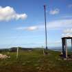
There is a marker cairn on the summit of Castlelaw Hill. Circular on plan, it measures about 2m in diameter by 0.4m in height and is composed of boulders and fragments of concrete broken off a nearby military sentry box (see CDTA05 106).
(CDTA05 14)
Visited by RCAHMS (AGCH), 6 June 2005.

