
Whitefield


Building(S) (Post Medieval), Farmstead (Medieval) - (Post Medieval)
Site Name Whitefield
Classification Building(S) (Post Medieval), Farmstead (Medieval) - (Post Medieval)
Canmore ID 27646
Site Number NO06SE 79
NGR NO 0905 6165
Datum OSGB36 - NGR
Permalink http://canmore.org.uk/site/27646


- Council Perth And Kinross
- Parish Kirkmichael (Perth And Kinross)
- Former Region Tayside
- Former District Perth And Kinross
- Former County Perthshire
Field Visit (August 1987)
NO06SE 79 0905 6165
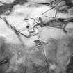
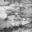
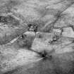
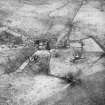
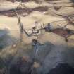
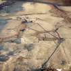
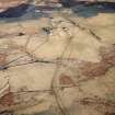
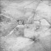
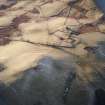
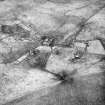
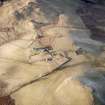
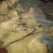
Immediately NE of the stone-walled enclosures associated with the ruinous farmstead of Whitefield there are the remains of two buildings. That on the NW (NO 0905 6171) is of two compartments, measures 23.3m from E to W by 6.2m transversely over stone wall-footings, and has an outshot at the E end.
That on the SE (NO 0909 6168) is of a single compartment, measures 16m from NW to SE transversely over a bank 0.2m high, and has an outshot at the SE end.
Visited by RCAHMS (PC) August 1987
RCAHMS 1990
Note (2 December 1997)
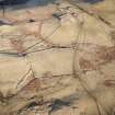
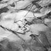
A farmstead comprising one roofed, four unroofed buildings, two of which are long buildings, and two enclosures is depicted on the 1st edition of the OS 6-inch map (Perthshire 1867, sheet xxxii). Two unroofed buildings, the remains of a third and an enclosure are shown on the current edition of the OS 1:10000 map (1977).
Information from RCAHMS (SAH) 2 December 1997.
Note (2 December 1997)
The second of the buildings described above by RCAHMS may be identified as part of one of the unroofed buildings shown on the 1st edition of the OS 6-inch map.
Information from RCAHMS (SAH) 2 December 1997.

