
Pricing Change
New pricing for orders of material from this site will come into place shortly. Charges for supply of digital images, digitisation on demand, prints and licensing will be altered.
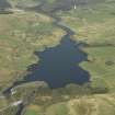
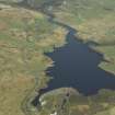
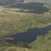
Carsfad Loch


Reservoir (Period Unassigned)
Site Name Carsfad Loch
Classification Reservoir (Period Unassigned)
Alternative Name(s) Carsfad Works; Carsfad Reservoir; Water Of Ken; Galloway Hydro-electric Scheme
Canmore ID 276212
Site Number NX68NW 104
NGR NX 607 860
NGR Description Centred NX 607 860
Datum OSGB36 - NGR
Permalink http://canmore.org.uk/site/276212


- Council Dumfries And Galloway
- Parish Kells
- Former Region Dumfries And Galloway
- Former District Stewartry
- Former County Kirkcudbrightshire
NX68NW 104 centred 607 860
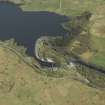
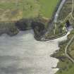
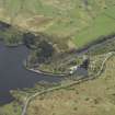
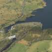
For Carsfad Loch, dam (NX 60656 85669), see NX68NW 25.00.
Carsfad Loch [NAT]
OS 1:10,000 map, 1981.
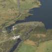
Catchment area: 171 sq miles (443 sq km)
Top water surface: 338ft (103m) OD
Surface area: 100 acres (41 ha)
Drawdown (daily maximum variation of level): c. 2ft (0.6m)
Anon. 1934 ['Galloway Water Power Scheme'].
Carsfad Loch (Reservoir) has been formed by damming the Water of Ken. It supplies water to Carsfad Power Station (NX68NW 26), and is a major component of Stage II of the Galloway Hydro-Electric Scheme.
This structure crosses the boundary between the parishes of Kells and Dalry.
Information from RCAHMS (RJCM), 21 October 2005.
Gibb and Partners et al. 1937.

