|
Prints and Drawings |
DC 14786 |
Records of the Royal Commission on the Ancient and Historical Monuments of Scotland (RCAHMS), Edinbu |
Ashintully Castle
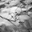
Overlay and base map showing distribution of sites in Dirnanean area. RCAHMS 1990,255 (NE Perth) |
|
Item Level |
|
|
Photographs and Off-line Digital Images |
D 76732 |
RCAHMS Aerial Photography |
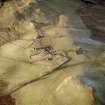
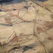
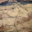
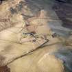
Oblique aerial view centred on the remains of the farmstead, buildings and tower-house, with the remains of the farmstead adjacent, taken from the E. |
29/1/2001 |
Item Level |
|
|
Photographs and Off-line Digital Images |
D 76734 |
RCAHMS Aerial Photography |
Oblique aerial view centred on the remains of the farmstead, buildings and tower-house, with the remains of the farmstead adjacent, taken from the NE. |
29/1/2001 |
Item Level |
|
|
Photographs and Off-line Digital Images |
D 69892 CN |
RCAHMS Aerial Photography |
Oblique aerial view centred on the remains of the farmstead, buildings and tower-house, with the remains of the farmstead adjacent, taken from the ESE. |
29/1/2001 |
Item Level |
|
|
Photographs and Off-line Digital Images |
D 69893 CN |
RCAHMS Aerial Photography |
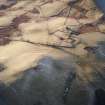
Oblique aerial view centred on the remains of the farmstead, buildings and tower-house, with the remains of the farmstead adjacent, taken from the NE. |
29/1/2001 |
Item Level |
|
|
Photographs and Off-line Digital Images |
D 69895 CN |
RCAHMS Aerial Photography |
Oblique aerial view centred on the remains of the farmstead, buildings and tower-house, with the remains of the farmstead adjacent, taken from the NW. |
29/1/2001 |
Item Level |
|
|
Photographs and Off-line Digital Images |
D 69901 CN |
RCAHMS Aerial Photography |
Oblique aerial view centred on the remains of the farmstead, buildings and tower-house, with the remains of the farmstead adjacent, taken from the SW. |
29/1/2001 |
Item Level |
|
|
Photographs and Off-line Digital Images |
D 69902 CN |
RCAHMS Aerial Photography |
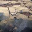
Oblique aerial view centred on the remains of the farmstead, buildings and tower-house, with the remains of the farmstead adjacent, taken from the SW. |
29/1/2001 |
Item Level |
|
|
Photographs and Off-line Digital Images |
D 69906 CN |
RCAHMS Aerial Photography |
Oblique aerial view centred on the remains of the farmstead, buildings and tower-house, with the remains of the farmstead adjacent, taken from the SSE. |
29/1/2001 |
Item Level |
|
|
Photographs and Off-line Digital Images |
D 76733 |
RCAHMS Aerial Photography |
Oblique aerial view centred on the remains of the farmstead, buildings and tower-house, with the remains of the farmsteads adjacent, taken from the E. |
29/1/2001 |
Item Level |
|
 |
On-line Digital Images |
SC 993225 |
RCAHMS Aerial Photography |
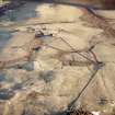
Scanned image of oblique aerial view centred on the remains of the farmstead, buildings and tower-house, with the remains of the farmstead adjacent, taken from the SSE. |
29/1/2001 |
Item Level |
|
 |
On-line Digital Images |
SC 1707687 |
RCAHMS Aerial Photography |
Oblique aerial view centred on the remains of the farmstead, buildings and tower-house, with the remains of the farmstead adjacent, taken from the ESE. |
29/1/2001 |
Item Level |
|
 |
On-line Digital Images |
SC 1707688 |
RCAHMS Aerial Photography |
Oblique aerial view centred on the remains of the farmstead, buildings and tower-house, with the remains of the farmstead adjacent, taken from the NE. |
29/1/2001 |
Item Level |
|
 |
On-line Digital Images |
SC 1707690 |
RCAHMS Aerial Photography |
Oblique aerial view centred on the remains of the farmstead, buildings and tower-house, with the remains of the farmstead adjacent, taken from the NW. |
29/1/2001 |
Item Level |
|
 |
On-line Digital Images |
SC 1707696 |
RCAHMS Aerial Photography |
Oblique aerial view centred on the remains of the farmstead, buildings and tower-house, with the remains of the farmstead adjacent, taken from the SW. |
29/1/2001 |
Item Level |
|
 |
On-line Digital Images |
SC 1707697 |
RCAHMS Aerial Photography |
Oblique aerial view centred on the remains of the farmstead, buildings and tower-house, with the remains of the farmstead adjacent, taken from the SW. |
29/1/2001 |
Item Level |
|
 |
On-line Digital Images |
SC 1707701 |
RCAHMS Aerial Photography |
Oblique aerial view centred on the remains of the farmstead, buildings and tower-house, with the remains of the farmstead adjacent, taken from the SSE. |
29/1/2001 |
Item Level |
|
 |
On-line Digital Images |
SC 1707709 |
RCAHMS Aerial Photography |
Oblique aerial view centred on the remains of the farmstead, buildings and tower-house, with the remains of the farmstead adjacent, taken from the E. |
29/1/2001 |
Item Level |
|
 |
On-line Digital Images |
SC 1707710 |
RCAHMS Aerial Photography |
Oblique aerial view centred on the remains of the farmstead, buildings and tower-house, with the remains of the farmsteads adjacent, taken from the E. |
29/1/2001 |
Item Level |
|
 |
On-line Digital Images |
SC 1707711 |
RCAHMS Aerial Photography |
Oblique aerial view centred on the remains of the farmstead, buildings and tower-house, with the remains of the farmstead adjacent, taken from the NE. |
29/1/2001 |
Item Level |
|
 |
On-line Digital Images |
SC 2395857 |
Records of the Ordnance Survey, Southampton, Hampshire, England |
Whitefield Castle, NO06SE 38, Ordnance Survey index card, Recto |
c. 1958 |
Item Level |
|


