
Creag Dubh-leitir, Gleann Fearnach


Farmstead (Medieval) - (Post Medieval)
Site Name Creag Dubh-leitir, Gleann Fearnach
Classification Farmstead (Medieval) - (Post Medieval)
Alternative Name(s) Castle Pirnie Cottage
Canmore ID 27593
Site Number NO06SE 30
NGR NO 0561 6411
Datum OSGB36 - NGR
Permalink http://canmore.org.uk/site/27593


- Council Perth And Kinross
- Parish Moulin
- Former Region Tayside
- Former District Perth And Kinross
- Former County Perthshire
Field Visit (19 January 1989)
NO06SE 30 056 641
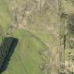
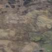
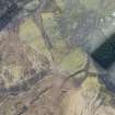
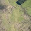
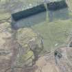
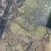
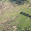
The remains of this farmstead lie within an area of rough, heather moorland some 410m E of Castle Pirnie cottage, but within a tract of ground bounded by the old head-dyke.
The principal building has two compartments and round-angles; it measures 12.7m NW-SE by 5m over turf-covered stone walls (0.8m thick and 0.6m high) which have been reduced to their lowest courses. There is an entrance to each compartment on the SW, and at the NW end there are the remains of an outshot (5.4m by 4m overall), also with an entrance on the SW.
A drainage-trench flanks the NE side of the building, and on the SW there is an enclosure which has been subdivided from NE-SW by a cross-wall.
On the NW side of this cross-wall there are traces of a second building (8.4m NE-SW by 4.5m over turf-covered stone wall-footings up to 0.6m thick).
A third building (13.1m WNW-ESE by 4.5m over turf-covered wall-footings 0.9m thick and 0.5m high), is situated a few metres to the SSW of the enclosure; it has two compartments, each with an entrance in the SSW wall.
A D-shaped enclosure lies immediately downslope from this building whilst a short distance to the WNW there are the remains of a small pen. A series of well-preserved lynchets extend upslope from the NW end of the farmstead.
Visited by RCAHMS (JRS) 19 January 1989.
RCAHMS 1990.

