
Following the launch of trove.scot in February 2025 we are now planning the retiral of some of our webservices. Canmore will be switched off on 24th June 2025. Information about the closure can be found on the HES website: Retiral of HES web services | Historic Environment Scotland
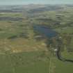
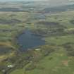
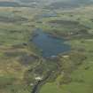
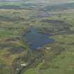
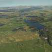
Earlstoun Loch


Reservoir (Period Unassigned)
Site Name Earlstoun Loch
Classification Reservoir (Period Unassigned)
Alternative Name(s) Earlstoun Works; Earlstoun Reservoir; Water Of Ken; Galloway Hydro-electric Scheme
Canmore ID 275894
Site Number NX68SW 28
NGR NX 612 830
NGR Description Centred NX 612 830
Datum OSGB36 - NGR
Permalink http://canmore.org.uk/site/275894


- Council Dumfries And Galloway
- Parish Dalry (Stewartry)
- Former Region Dumfries And Galloway
- Former District Stewartry
- Former County Kirkcudbrightshire
NX68SW 28.00 centred 612 830
NX68SW 28.01 NX 61376 82308 to NX 61490 82425 Dam
NX68SW 28.02 NX 61370 82311 to NX 61338 81948 Aqueduct; Dam ('Earlstoun canal')
For associated Earlstoun Power Station (NX 61410 81879), see NX68SW 147.
Earlstoun Loch (Reservoir)
Top water level 74 metres above Newlyn datum [NAT]
OS 1:10,000 map, 1982.
Catchment area: 193 sq miles (500 sq km)
Top water surface: 245ft (75m) OD
Surface area: 140 acres (57 ha)
Drawdown (daily maximum variation of level): c. 2ft (0.6m)
Anon. 1934 ['Galloway Water Power Scheme'].
This reservoir supplies water to Earlstoun Power Station (NX68SW 147). It forms a major element of stage II of the Galloway Hydro-Electric Scheme
Information from RCAHMS (RJCM), 25 October 2005.

