 |
On-line Digital Images |
SC 1401828 |
Records of the Royal Commission on the Ancient and Historical Monuments of Scotland (RCAHMS), Edinbu |
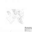
RCAHMS survey drawing: Tulloch Field, Enochdhu site plan 1:1000 |
8/2013 |
Item Level |
|
 |
On-line Digital Images |
SC 1401833 |
Records of the Royal Commission on the Ancient and Historical Monuments of Scotland (RCAHMS), Edinbu |
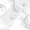
RCAHMS publication illustration: Tulloch Field, Enochdhu site plan. |
2013 |
Item Level |
|
 |
On-line Digital Images |
SC 1405999 |
Records of the Royal Commission on the Ancient and Historical Monuments of Scotland (RCAHMS), Edinbu |
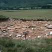
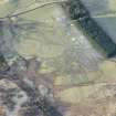
Tulloch Field Site B 1982, end of excavation. 0.5m ranging pole divisions. |
1982 |
Item Level |
|
 |
On-line Digital Images |
SC 1406001 |
Records of the Royal Commission on the Ancient and Historical Monuments of Scotland (RCAHMS), Edinbu |
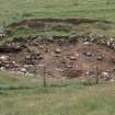
Tulloch Field Site A 1979, end of season. 0.5m ranging pole divisions. |
1979 |
Item Level |
|
 |
On-line Digital Images |
SC 1406002 |
Records of the Royal Commission on the Ancient and Historical Monuments of Scotland (RCAHMS), Edinbu |
Tulloch Field Site A 1979, FN90 charcoal |
1979 |
Item Level |
|
 |
On-line Digital Images |
SC 1406009 |
Records of the Royal Commission on the Ancient and Historical Monuments of Scotland (RCAHMS), Edinbu |
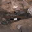
Tulloch Field Site B 1981. FN 10, hearth pit. 0.5m ranging pole divisions |
1981 |
Item Level |
|
 |
On-line Digital Images |
SC 1406010 |
Records of the Royal Commission on the Ancient and Historical Monuments of Scotland (RCAHMS), Edinbu |
Tulloch Field Site B 1981. FN 10, hearth pit. 0.5m ranging pole divisions. |
1981 |
Item Level |
|
 |
On-line Digital Images |
SC 1406012 |
Records of the Royal Commission on the Ancient and Historical Monuments of Scotland (RCAHMS), Edinbu |
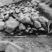
Tulloch Field Site A 1977, section through wall (south-east section). 0.5m ranging pole divisions. |
1977 |
Item Level |
|
 |
On-line Digital Images |
SC 1406013 |
Records of the Royal Commission on the Ancient and Historical Monuments of Scotland (RCAHMS), Edinbu |
Tulloch Field Site A 1978. 0.5m ranging pole divisions. |
1978 |
Item Level |
|
 |
On-line Digital Images |
DP 228938 |
Historic Environment Scotland |
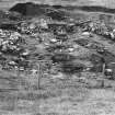
Oblique aerial view of the hut circles, townships, farmsteads, field boundaries and rig at Craig Dubh-Leitir, looking W. |
15/1/2016 |
Item Level |
|
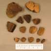 |
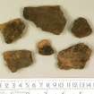
On-line Digital Images |
DP 303724 |
Lis Thoms |
Low resolution jpeg of pottery from excavation. |
8/1/2014 |
Item Level |
|
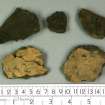 |
On-line Digital Images |
DP 303725 |
Lis Thoms |
Low resolution jpeg of pottery from excavation. |
8/1/2014 |
Item Level |
|
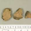 |
On-line Digital Images |
DP 303726 |
Lis Thoms |
Low resolution jpeg of pottery from excavation. |
8/1/2014 |
Item Level |
|
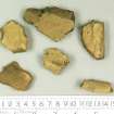 |
On-line Digital Images |
DP 303727 |
Lis Thoms |
Low resolution jpeg of pottery from excavation. |
8/1/2014 |
Item Level |
|
 |
On-line Digital Images |
DP 303728 |
Lis Thoms |
Low resolution jpeg of pottery from excavation. |
8/1/2014 |
Item Level |
|
 |
On-line Digital Images |
SC 2395829 |
Records of the Ordnance Survey, Southampton, Hampshire, England |
Tulloch Field, Enochdhu, NO06SE 20, Ordnance Survey index card, page number 1, Recto |
c. 1958 |
Item Level |
|
 |
On-line Digital Images |
SC 2395830 |
Records of the Ordnance Survey, Southampton, Hampshire, England |
Tulloch Field, Enochdhu, NO06SE 20, Ordnance Survey index card, page number 2, Verso |
c. 1958 |
Item Level |
|
 |
On-line Digital Images |
SC 2395831 |
Records of the Ordnance Survey, Southampton, Hampshire, England |
Tulloch Field, Enochdhu, NO06SE 20, Ordnance Survey index card, page number 3, Recto |
c. 1958 |
Item Level |
|
 |
On-line Digital Images |
SC 2395832 |
Records of the Ordnance Survey, Southampton, Hampshire, England |
Tulloch Field, Enochdhu, NO06SE 20, Ordnance Survey index card, page number 4, Verso |
c. 1958 |
Item Level |
|
 |
On-line Digital Images |
SC 2395833 |
Records of the Ordnance Survey, Southampton, Hampshire, England |
Tulloch Field, Enochdhu, NO06SE 20, Ordnance Survey index card, Recto |
c. 1958 |
Item Level |
|


