
Ardintoul House


House (Period Unassigned)
Site Name Ardintoul House
Classification House (Period Unassigned)
Canmore ID 275622
Site Number NG82SW 22
NGR NG 83345 24167
Datum OSGB36 - NGR
Permalink http://canmore.org.uk/site/275622

- Council Highland
- Parish Glenshiel
- Former Region Highland
- Former District Skye And Lochalsh
- Former County Ross And Cromarty
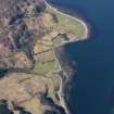
Ardintoul Remote only since Loch Duich ceased to be a principal thoroughfare, this settlement on the crescent of Ardintoul Bay is accessible today by foot from Totaig, or forestry track via Glen Bernera.
Ardintoul House, 18th century; later additions A wide-gabled, steep-roofed tacksman's house, still prominent beside a stand of trees. Most significant of its various ancillary buildings is the ruin of a 70 ft long Kintail barn, formerly with timber louvred sides, now reduced to rubble stumps within which the footings of cruck blades are still embedded.
Taken from "Western Seaboard: An Illustrated Architectural Guide", by Mary Miers, 2008. Published by the Rutland Press http://www.rias.org.uk

NG82SW 22 83345 24167
Ardintoul is situated on the S bank of Loch Alsh at the SW edge of Ardintoul Bay, within an enclosure of conifer trees.
It is depicted as roofed on the 1st Edition of the OS 6-inch map (Ross and Cromarty, 1880, sheet sheet cxxvii). By the date of the 2nd edition (ibid, 1903-1904), the only changes were the addition of a 'boat house' at high water mark about 70m NE of the house and the disappearance of a small roofed building to the W.
Information from RCAHMS (DE), October 2008

