|
Prints and Drawings |
DC 14785 |
Records of the Royal Commission on the Ancient and Historical Monuments of Scotland (RCAHMS), Edinbu |
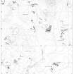
Overlay and base map showing distribution of monuments in the Dirnanean area. NE Perth Inv 121 |
c. 1989 |
Item Level |
|
 |
On-line Digital Images |
DP 226357 |
RCAHMS Aerial Photography Digital |
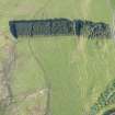
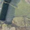
Oblique aerial view of the townships, field system and rig at Gleann Fearnach on the slopes of Creag Dubh Leitir, looking ESE. |
25/5/2015 |
Item Level |
|
 |
On-line Digital Images |
DP 226358 |
RCAHMS Aerial Photography Digital |
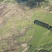
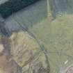
Oblique aerial view of the townships, field system and rig at Gleann Fearnach on the slopes of Creag Dubh Leitir, looking E. |
25/5/2015 |
Item Level |
|
 |
On-line Digital Images |
DP 226359 |
RCAHMS Aerial Photography Digital |
Oblique aerial view of the townships, field system and rig at Gleann Fearnach on the slopes of Creag Dubh Leitir, looking E. |
25/5/2015 |
Item Level |
|
 |
On-line Digital Images |
DP 226360 |
RCAHMS Aerial Photography Digital |
Oblique aerial view of the townships, field system and rig at Gleann Fearnach on the slopes of Creag Dubh Leitir, looking NE. |
25/5/2015 |
Item Level |
|
 |
On-line Digital Images |
DP 228949 |
Historic Environment Scotland |
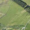
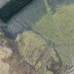
Oblique aerial view of the townships, farmsteads, field boundaries and rig at Craig Dubh-Leitir, looking SW. |
15/1/2016 |
Item Level |
|
 |
On-line Digital Images |
DP 228951 |
Historic Environment Scotland |
Oblique aerial view of the townships, farmsteads, field boundaries and rig at Craig Dubh-Leitir, looking SSE. |
15/1/2016 |
Item Level |
|
 |
On-line Digital Images |
DP 228952 |
Historic Environment Scotland |
Oblique aerial view of the townships, farmsteads, field boundaries and rig at Craig Dubh-Leitir, looking SSE. |
15/1/2016 |
Item Level |
|
 |
On-line Digital Images |
DP 228954 |
Historic Environment Scotland |
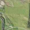
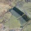
Oblique aerial view of the townships, farmsteads, field boundaries and rig at Craig Dubh-Leitir, looking E. |
15/1/2016 |
Item Level |
|
 |
On-line Digital Images |
SC 2191538 |
Records of the Royal Commission on the Ancient and Historical Monuments of Scotland (RCAHMS), Edinbu |
Overlay and base map showing distribution of monuments in the Dirnanean area. NE Perth Inv 121 |
c. 1989 |
Item Level |
|
 |
On-line Digital Images |
SC 2395941 |
Records of the Ordnance Survey, Southampton, Hampshire, England |
Creag Dubh-Leitir, Gleann Fearnach, NO06SE 121, Ordnance Survey index card, Recto |
c. 1958 |
Item Level |
|


