
Pricing Change
New pricing for orders of material from this site will come into place shortly. Charges for supply of digital images, digitisation on demand, prints and licensing will be altered.
Upcoming Maintenance
Please be advised that this website will undergo scheduled maintenance on the following dates:
Thursday, 9 January: 11:00 AM - 3:00 PM
Thursday, 23 January: 11:00 AM - 3:00 PM
Thursday, 30 January: 11:00 AM - 3:00 PM
During these times, some functionality such as image purchasing may be temporarily unavailable. We apologise for any inconvenience this may cause.
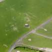
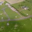
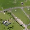
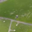
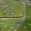
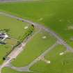
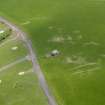
Errol Airfield, Watch Tower


Control Tower (20th Century)
Site Name Errol Airfield, Watch Tower
Classification Control Tower (20th Century)
Canmore ID 275302
Site Number NO22SE 18.02
NGR NO 27098 24590
Datum OSGB36 - NGR
Permalink http://canmore.org.uk/site/275302


- Council Perth And Kinross
- Parish Errol
- Former Region Tayside
- Former District Perth And Kinross
- Former County Perthshire
NO22Se 18.02 27098 24590
The derelict control tower is situated about 50m inside the perimeter track on the N side of the airfield.
The tower is visible on RAF WW II vertical air photographs (NLA 68, 3089-3090, flown 27 August 1943), as a square falt-roofed building orientated NW-SE. The photographs also show that there were three smaller buildings and an emergency air-raid shelter immediately to the SW, all of which have since been removed.
Information from RCAHMS (DE), September 2005

