Accessibility

Font Size

100% 150% 200%

Background Colour

Default Contrast
Close Reset

Strathblane

Village (Period Unassigned)

Site Name Strathblane

Classification Village (Period Unassigned)

Canmore ID 275191

Site Number NS57NE 93

NGR NS 5629 7924

Datum OSGB36 - NGR

Permalink http://canmore.org.uk/site/275191
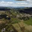
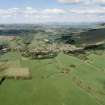
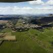
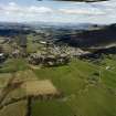
Ordnance Survey licence number AC0000807262. All rights reserved.
Canmore Disclaimer. © Bluesky International Limited 2025. Public Sector Viewing Terms

Toggle Aerial | View on large map

Digital Images

General oblique aerial view looking across the villages towards Loch Lomond and the Trossachs beyond, taken from the SE.
General oblique aerial view looking across the villages towards Loch Lomond and the Trossachs beyond, taken from the SE.General oblique aerial view looking across the villages towards Loch Lomond and the Trossachs beyond, taken from the SE.General oblique aerial view looking across the villages towards Loch Lomond and the Trossachs beyond, taken from the SE.General oblique aerial view looking across the villages towards Loch Lomond and the Trossachs beyond, taken from the SE.

Administrative Areas

  • Council Stirling
  • Parish Strathblane (Stirling)
  • Former Region Central
  • Former District Stirling
  • Former County Stirlingshire

References

MyCanmore Image Contributions


Contribute an Image

MyCanmore Text Contributions