
Pricing Change
New pricing for orders of material from this site will come into place shortly. Charges for supply of digital images, digitisation on demand, prints and licensing will be altered.
Brunton Barns-star-sandy Hill


Anti Tank Ditch (20th Century)
Site Name Brunton Barns-star-sandy Hill
Classification Anti Tank Ditch (20th Century)
Alternative Name(s) Fife Anti-tank Line; Command Line
Canmore ID 275095
Site Number NO30SW 30
NGR NO 3137 0373
NGR Description NO 3071 0187 to NO 3091 0499
Datum OSGB36 - NGR
Permalink http://canmore.org.uk/site/275095


- Council Fife
- Parish Kennoway
- Former Region Fife
- Former District Kirkcaldy
- Former County Fife
NO30SW 30.00 3071 0187 to 3091 0499
NO30SW 30.01 NO 3087 0303 Anti-tank Wall
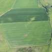
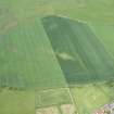
A section of the Fife Anti-tank or Command Line has been identified from vertical air photographs (106G/Scot/UK 5, 3030-3032, 4030-4032, flown 4 April 1946).
The course of the anti-tank ditch is clearly visible on the photographs z-g-zagging N across fields from near the farm of Brunton Barns (NO30SW 116) to the E side of Cuinin Hill through the village of Star on passing to the E of Sandy Hill on to map sheet NO30NW.
Additonal to the ditch are an anti-tank wall (NO30SW 30.01) on the southern approach to Star village and another length of wall protecting the E side of the railway embankment at Northall (NO30SW 28) and a pillbox built to house an anti-tank gun W of Whitehill Plantation (NO30SW 29).
No sections of this part of the ditch appear to have survived.
Information from RCAHMS (DE), September 2005.

