
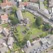
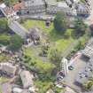
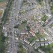
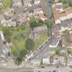
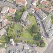
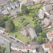
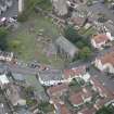
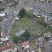
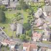
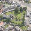
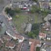
Edinburgh, Restalrig Road South, Restalrig Parish Church, Churchyard


Churchyard (17th Century)
Site Name Edinburgh, Restalrig Road South, Restalrig Parish Church, Churchyard
Classification Churchyard (17th Century)
Canmore ID 275067
Site Number NT27SE 103.04
NGR NT 28314 74452
Datum OSGB36 - NGR
Permalink http://canmore.org.uk/site/275067


- Council Edinburgh, City Of
- Parish Edinburgh (Edinburgh, City Of)
- Former Region Lothian
- Former District City Of Edinburgh
- Former County Midlothian
NT27SE 103.04 28314 74452
NT 2834 7446 The former entrance to Restalrig Churchyard lies S of the restored church. On the inner face of the blocking, against the N pillar, is a stone sphere of pale grey sandstone, approximately 0.3m in diameter, with discolouring due to weathering. It may be an unused cannonball.
C A-Kelly 2004
INVENTORY OF GRAVEYARD AND CEMETERY SITES IN SCOTLAND REFERENCE:
Address: Restalrig Parish Church Churchyard, Restalrig Road South, Edinburgh
Postcode: EH7 6LF
Status: Closed for burials but maintained
Size: 0.35 hectares, 0.86 acres
Polygon: No
TOIDs:
Number of gravestones: Not known
Earliest gravestone: Not known
Most recent gravestone: Not Known
Description: Burial ground associated with a church.
Data Sources: OS MasterMap checked 15 September 2005; Bereavement Services Portal checked 15 September 2005
Publication Account (1951)
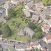
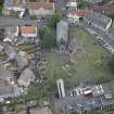
220. Parish Church, Restalrig.
On being rebuilt in 1487, the old parish church, which appears on record as early as the 12th century, was erected by King James III into a collegiate establishment known as the Deanery of Restalrig (1). At the Reformation it was the first church in Scotland to suffer. On 21st December 1560 the General Assembly directed ‘that the kirk of Restalrig, as a monument of idolatrie, be raysit and utterlie castin downe and destroyed’ (2), and thereafter its ruins served as a quarry. In 1571 some of the stones which had already been removed to Edinburgh for house building were diverted to the reconstruction of the Nether Bow Port (3). Some parts of the choir walls, however, escaped destruction, and these were restored in 1836 to make the church of a quoad sacra parish.
As it stands to-day this building is featureless and shows few traces of its 15th-century origin. It is built of rubble, the lower part of the walls being offset, with buttresses of ashlar, the south-easternmost of which exhibits a weatherworn panel carved with a shield surmounted by a crown, the arms and supporters being wholly illegible. There were no windows in the N. wall, and three built-up doorways in the lower part of it seem to be late insertions. The E. window and three of the four windows facing S., as well as a built-up doorway on the S. side, which has a semicircular head and is enriched with small carved paterae, all date from 1487. Attached to the S.W. angle of the church is St. Triduana's Well, a most interesting piece of architecture, which originally formed the undercroft of St. Triduana's Chapel [NT27SE 103.01]. The Chapel was already in existence some ten years before the church itself came to be rebuilt. Prior to its restoration in 1907 the little building had been thought to be either a chapter-house or a burial-vault, but the excavation then made revealed its purpose as a ‘Balm Well’* and disclosed evidence of there having been an upper storey, obviously the ‘Upper Chapel’ endowed by King James III in 1477 (4). In the restoration** only the undercroft could be taken in hand, as certain evidence essential to the rebuilding of the superstructure was lacking.
Built partly below ground, the structure is hexagonal on plan, the external diameter measuring 36 ft. 6 in. The masonry is ashlar. Each angle has been reinforced by a projecting buttress. In each of the three S. sides is a late Gothic window, its sill level with the ground outside. These windows are mullioned and the reprises are unusually high. Their heads are three-centred, a form not commonly seen in Scotland, and they contain moulded and cusped tracery in which the eyes are unpierced. Their jamb-section is chamfered and quirked. The original entrance in the N.W. wall has been rebuilt. The N. wall contains a wide built-up doorway which once led from the church. There is no opening in the N.E. wall, which must therefore have abutted against some other structure. The outer side of the E. wall partly overrides a moulded base of 13th-century date, apparently the only vestige of the first building.
The undercroft and the upper chapel were both vaulted, and the lower of the two rib-vaults, which is still extant, is possibly the most interesting feature of the interior. There is a central pier, composed of clustered shafts with fillets, and within each angle of the cell a wall-shaft rises as a respond. The method by which a polygonal building is normally vaulted is to spring vault-ribs in semicircular or pointed arcs from pier to wall-shaft, but here the arcs are sprung instead from the wall shaft at one angle to that at the angle opposite, while the mid- or ridge-rib first runs horizontally to an intermediate boss and then sweeps downwards to the capital of the pier. Four of the vaulting bosses are foliaceous, while two others have shields, both uncarved. The mouldings and carved work on the ribs, capitals and bases are characteristic of the third quarter of the 15th century. On each wall is a stone bench, to the top of which the water now frequently rises.
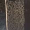
According to Arnot (5), who wrote in 1788, the place had been used for burial some centuries earlier. An interesting sepulchral slab can be seen built into the N.E. wall, but this stone is not in its original position and may have been brought in from outside. Below the initials I K is incised a shield parted per pale and charged: Dexter, quarterly, 1st and 4th three piles in point, for Logan, 2nd, an eagle displayed, for Restalrig, 3rd, three papingoes, for Pepdie and Home; sinister, on a chevron, three mullets, for Ker. Round the margin runs an inscription, the last two lines of which are cut below the first one, with the result that the breakage of the left-hand top corner has led to the loss of some words in all three. The missing words are, however, on record, (6) and when they are supplied the whole reads: [HERE LYETH] ANE / HONORABLE LADY IONET KER / LADY RESTAL/RIG QVHA DEPAERTIT YIS L[YFE / 12 DAY OF M]AII / [ANNO 15]96. In describing the stone (7) the late Mr. William Douglas pointed out that the date as given above seemed to identify the deceased as the second wife of the Gowrie conspirator, Robert Logan, seventh laird of Restalrig.
ARCHITECTURAL FRAGMENTS.
Within the roof space above the rib-vault are preserved a number of carved and moulded fragments, evidently part of the upper chapel. Others are grouped outside the entrance, but the most noteworthy have been placed within the undercroft. The collection includes:
(1) Moulded bases, and sections of window tracery.
(2) A vaulting boss with a star of five points enclosed by stiff, conventional foliage.
(3) Another boss with a shield similarly enclosed, on which the letters I M, for Iesus Maria, appear in monogram, beneath a crown and flanked by two doves.
(4) A third boss similar to the last with the letters I H S beneath a crown.
(5) A fourth boss, bearing a saltire cantoned with four fleurs-de-lys, the arms of Kelly of that Ilk.
(6) A- grotesque head.
FONT. An interesting font of the 13th century, which lay for many years in the courtyard of Craigentinny House (RCAHMS 1951, No. 231), has recently been restored to the church. It is in the form of a drum of stone with four projecting lugs, and measures 1 ft. 6 in.in diameter by 1 ft. in height. The bowl is 1 ft. ½ in.in diameter and 8½ in. deep. The drum has been designed to stand on a circular shaft.
JOUGS [NT27SE 103.02]. In the boundary wall S.E. of the church is a built-up and incomplete gateway of the 17th century, to one jamb of which is attached a pair of jougs with a modern collar.
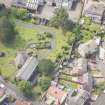
TOMBSTONES NT27SE 103.04. The churchyard contains a late 17th- or early 18th-century table-stone, and two headstones of the same time. None of the inscriptions is legible.
RCAHMS 1951, visited c.1941
(1) Laing, Collegiate Churches, pp. iv and xiv. (2) The Rooke of the Universall Kirk of Scotland, p., 5. (3) Diurnal, p. 241. (4) Laing, op. cit., p. xlv. (5) History, p. 257. (6) Laing, op. cit., p. lxi, where the date has been read incorrectly. (7) P.S.A.S., lxii (1927-8),pp. 27-35.
*Traditionally Restalrig was not only the scene of St.Triduana's life but also her burial-place. After her death it became a pilgrim resort for those afflicted with diseases of the eyes, and as late as the 16th century Sir David Lindsay speaks of people going there "to mend their ene".
**Of which a full account will be found in the Transactions of the Scottish Ecclesiological Society, iii, pp. 238 ff.
Project (1997)
The Public Monuments and Sculpture Association (http://www.pmsa.org.uk/) set up a National Recording Project in 1997 with the aim of making a survey of public monuments and sculpture in Britain ranging from medieval monuments to the most contemporary works. Information from the Edinburgh project was added to the RCAHMS database in October 2010 and again in 2012.
The PMSA (Public Monuments and Sculpture Association) Edinburgh Sculpture Project has been supported by Eastern Photocolour, Edinburgh College of Art, the Edinburgh World Heritage Trust, Historic Scotland, the Hope Scott Trust, The Old Edinburgh Club, the Pilgrim Trust, the RCAHMS, and the Scottish Archive Network.
Watching Brief (9 March 2009 - 11 March 2009)
An excavation was carried out in the graveyard of St Triduana's Chapel (Restalrig Parish Church) to locate a drain known to run from the chapel to the street to the east. A cutter sent by contractors into this drain to clear it had become stuck within the drain, and the hope was that this could be recovered. This proved difficult due to the presence of the roots of a nearby tree, which had greatly affected the area, although what was very likely to be the cut for the drain was seen. Work was abandoned at this stage.
Information from Claire Case (Kirkdale Archaeology) 30 March 2009. OASIS ID: kirkdale1-249697
Ground Penetrating Radar (26 October 2022)
Historic Environment Scotland (HES), Archaeological Survey Team, undertook Ground Penetrating Radar survey at Restalrig Kirkyard, City of Edinburgh, Scotland, to identify the location of buried services within Restalrig Kirkyard. The survey was conducted on 26 October 2022. In total 0.04 ha were surveyed with a MALÅ GX Ground Penetrating Radar device.
The survey results are summarised below, drawing out the main points from a comprehensive report outlining methodology and detailed results [1]. The archive also includes the unprocessed survey data, processed survey data [2].
The geophysical survey has produced poor quality ground penetrating radar results especially in the area believed to contain the drain, and so has only been partially successful in achieved the aims. The poor results are linked to the level of disturbance in the kirkyard. Despite this there is a high level of confidence that the chosen methodology and survey strategy was appropriate to assess the archaeological potential of the survey area and a different survey method would not have produced better quality results.
The survey has identified a feature running east to west which may represent the drain as it links the location of the drain cover with the Kirk. The bioturbation in the area makes it difficult to confirm this and impossible to estimate the depth of this feature. The survey has also detected the course of the old pathway running to the south of the Kirk and identified several targets which may mark the location of unmarked burials.
Visited by HES Archaeological Survey (N. Hannon, H. Blake, M. Young, I. Shaw) 26 October 2022
[1] http://canmore.org.uk/collection/???????
[2] http://canmore.org.uk/collection/???????

