
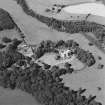
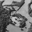
Caprington


Rig And Furrow (Medieval) - (Post Medieval)
Site Name Caprington
Classification Rig And Furrow (Medieval) - (Post Medieval)
Canmore ID 274938
Site Number NS43NW 421
NGR NS 4045 3637
Datum OSGB36 - NGR
Permalink http://canmore.org.uk/site/274938


- Council East Ayrshire
- Parish Riccarton
- Former Region Strathclyde
- Former District Kilmarnock And Loudoun
- Former County Ayrshire
NS43NW 421 4045 3637
A large block of narrow straight rig, oriented roughly from NE to SW, has been recorded on oblique aerial photography (RCAHMSAP 1999) on level ground on the S bank of the River Irvine.
Information from RCAHMS (KMM) 16 August 2005

