
Islay, Dun Guaidhre


Rig And Furrow (Medieval) - (Post Medieval)
Site Name Islay, Dun Guaidhre
Classification Rig And Furrow (Medieval) - (Post Medieval)
Canmore ID 273259
Site Number NR36SE 67
NGR NR 3880 6476
Datum OSGB36 - NGR
Permalink http://canmore.org.uk/site/273259


- Council Argyll And Bute
- Parish Killarow And Kilmeny
- Former Region Strathclyde
- Former District Argyll And Bute
- Former County Argyll
NR36SE 67 3880 6476
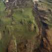
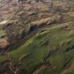
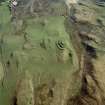
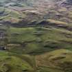
A small patch of rig, oriented roughly N-S, has been recorded on oblique aerial photography (RCAHMSAP 2005) lying on gently sloping ground immediately SW of Dun Guairhre.
Information from RCAHMS (KMM) 11 July 2005

